IMAGES TAKEN NEAR TO
Brookfield Close, ASHTEAD, KT21 2GA
Introduction
This page details the photographs taken nearby to Brookfield Close, KT21 2GA by members of the Geograph project.
The Geograph project started in 2005 with the aim of publishing, organising and preserving representative images for every square kilometre of Great Britain, Ireland and the Isle of Man.

There are currently over 7.5m images from over14,400 individuals and you can help contribute to the project by visiting https://www.geograph.org.uk
Image Map
Images are licensed for reuse under creativecommons.org/licenses/by-sa/2.0
Notes
- Clicking on the map will re-center to the selected point.
- The higher the marker number, the further away the image location is from the centre of the postcode.
Image Listing (3 Images Found)
Images are licensed for reuse under creativecommons.org/licenses/by-sa/2.0
Image
Details
Distance
1
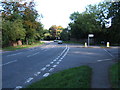
A24 at the junction with The Warren
Looking towards Epsom.
Image: © Roger Miller
Taken: 2 Oct 2005
0.16 miles
2
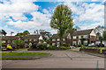
Taleworth Road
Crescent off Ottway's Lane, with this section developed in the 1960s/70s.
Image: © Ian Capper
Taken: 28 Apr 2017
0.18 miles
3
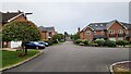
Bramley Grove
Housing infill development on a school site.
Image: © James Emmans
Taken: 4 Sep 2021
0.23 miles