IMAGES TAKEN NEAR TO
Woodfield Road, ASHTEAD, KT21 2DZ
Introduction
This page details the photographs taken nearby to Woodfield Road, KT21 2DZ by members of the Geograph project.
The Geograph project started in 2005 with the aim of publishing, organising and preserving representative images for every square kilometre of Great Britain, Ireland and the Isle of Man.

There are currently over 7.5m images from over14,400 individuals and you can help contribute to the project by visiting https://www.geograph.org.uk
Image Map
Images are licensed for reuse under creativecommons.org/licenses/by-sa/2.0
Notes
- Clicking on the map will re-center to the selected point.
- The higher the marker number, the further away the image location is from the centre of the postcode.
Image Listing (70 Images Found)
Images are licensed for reuse under creativecommons.org/licenses/by-sa/2.0
Image
Details
Distance
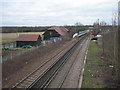
1
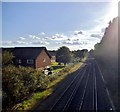
The railway between Ashtead and Leatherhead
Image: © David Howard
Taken: 31 Aug 2014
0.02 miles
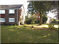
4
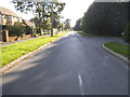
Woodfield Road, Ashtead
Running along the edge of Ashtead Common
Image: © David Howard
Taken: 31 Aug 2014
0.05 miles
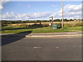
5
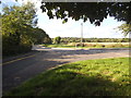
Links Road, Ashtead
Links Road runs along the north side of the railway line and ends at the border with Leatherhead at a dead end.
Image: © David Howard
Taken: 31 Aug 2014
0.06 miles
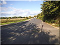
7
Links Road at the junction of Ashtead Woods Road
Image: © David Howard
Taken: 31 Aug 2014
0.06 miles
8
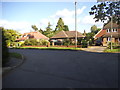
The entrance to Ashtead Common
From Links Road
Image: © David Howard
Taken: 31 Aug 2014
0.08 miles
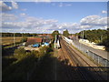
9
Ashtead Common Depot and Ashtead Station
Taken from the footbridge over the railway.
Image: © Danny P Robinson
Taken: 28 Jan 2007
0.08 miles
10
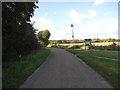
Ashtead station from the footbridge
The bridge goes from next to the station to the common you can see on the left.
Image: © David Howard
Taken: 31 Aug 2014
0.09 miles