IMAGES TAKEN NEAR TO
Walters Mead, ASHTEAD, KT21 2BP
Introduction
This page details the photographs taken nearby to Walters Mead, KT21 2BP by members of the Geograph project.
The Geograph project started in 2005 with the aim of publishing, organising and preserving representative images for every square kilometre of Great Britain, Ireland and the Isle of Man.

There are currently over 7.5m images from over14,400 individuals and you can help contribute to the project by visiting https://www.geograph.org.uk
Image Map
Images are licensed for reuse under creativecommons.org/licenses/by-sa/2.0
Notes
- Clicking on the map will re-center to the selected point.
- The higher the marker number, the further away the image location is from the centre of the postcode.
Image Listing (20 Images Found)
Images are licensed for reuse under creativecommons.org/licenses/by-sa/2.0
Image
Details
Distance
1
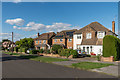
Hillside Road
Housing first marked on the 1955-63 1:2,500 map.
Image: © Ian Capper
Taken: 7 Sep 2018
0.09 miles
3
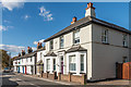
Woodfield Lane
Housing on Woodfield Lane, next to where Woodfield Farm once stood. The terrace in the background, nos 70 - 80, are shown on the 1877 1:2,500 map, whereas the nearer two houses, nos 66 and 68, first appear on the 1895 edition.
Image: © Ian Capper
Taken: 7 Sep 2018
0.11 miles
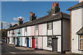
4
Cottages, Woodfield Lane, Ashtead
At the northern end of Woodfield Lane near Ashtead pond.
Image: © Thomas Grant
Taken: 11 May 2007
0.11 miles
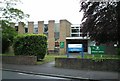
5
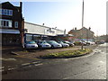
Volkspeed car dealership, Craddocks Parade, Ashtead
Image: © Stacey Harris
Taken: 12 Dec 2010
0.12 miles
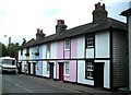
6
70 - 80 Woodfield Lane
Terrace of cottages on Woodfield Lane, next to where Woodfield Farm once stood. It is shown on the 1877 1:2,500 map.
Image: © Ian Capper
Taken: 7 Sep 2018
0.12 miles
7
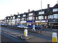
Shopping parade, Craddocks Avenue, Ashtead
Image: © Stacey Harris
Taken: 12 Dec 2010
0.14 miles
8
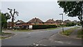
Bramley Way
Junction with Cray Avenue and Berry Meade.
Image: © James Emmans
Taken: 4 Sep 2021
0.15 miles
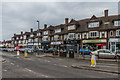
9
Shopping parade, Craddocks Avenue, Ashtead
Image: © Stacey Harris
Taken: 12 Dec 2010
0.15 miles
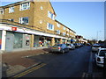
10
Craddocks Parade
1938 shopping parade in Craddocks Avenue, by its junction with Woodfield Lane. Both names commemorate the same farm - Craddock's Farm was the original name of Woodfield Farm, the buildings of which had previously stood on this site.
Image: © Ian Capper
Taken: 20 Jul 2018
0.16 miles