IMAGES TAKEN NEAR TO
Woodfield Lane, ASHTEAD, KT21 2BH
Introduction
This page details the photographs taken nearby to Woodfield Lane, KT21 2BH by members of the Geograph project.
The Geograph project started in 2005 with the aim of publishing, organising and preserving representative images for every square kilometre of Great Britain, Ireland and the Isle of Man.

There are currently over 7.5m images from over14,400 individuals and you can help contribute to the project by visiting https://www.geograph.org.uk
Image Map
Images are licensed for reuse under creativecommons.org/licenses/by-sa/2.0
Notes
- Clicking on the map will re-center to the selected point.
- The higher the marker number, the further away the image location is from the centre of the postcode.
Image Listing (15 Images Found)
Images are licensed for reuse under creativecommons.org/licenses/by-sa/2.0
Image
Details
Distance
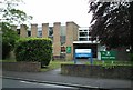
2
Hillside Road
Housing first marked on the 1955-63 1:2,500 map.
Image: © Ian Capper
Taken: 7 Sep 2018
0.16 miles
3
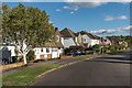
Hillside Road
Housing first marked on the 1955-63 1:2,500 map.
Image: © Ian Capper
Taken: 7 Sep 2018
0.19 miles
4
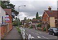
Woodfield Lane
A turning off Ashtead's main road, The Street. In the distance, on the right, is the Ashtead Peace Memorial Hall. Image
Image: © P L Chadwick
Taken: 14 Aug 2010
0.20 miles
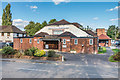
5
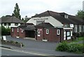
Ashtead Peace Memorial Hall, Woodfield Lane
This is the village hall, which is centrally placed. It has a large main hall with stage, two function rooms, a licensed bar and a resident caretaker. It has charitable status, and is run by a Board of Trustees. Funds were raised for the hall in the early 1920's, and it eventually opened in November 1924. There have been alterations over the years, to meet changing needs.
Image: © P L Chadwick
Taken: 14 Aug 2010
0.20 miles
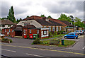
6
Ashtead Peace Memorial Hall
Community Hall in Woodfield Lane, opened on 3 November 1924.
Image: © Ian Capper
Taken: 7 Sep 2018
0.20 miles
7
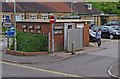
Public convenience, Woodfield Lane
Located just inside the public car park, by Ashtead Peace Memorial Hall.
Image: © P L Chadwick
Taken: 14 Aug 2010
0.21 miles
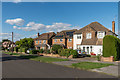
8
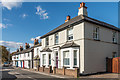
Woodfield Lane
Housing on Woodfield Lane, next to where Woodfield Farm once stood. The terrace in the background, nos 70 - 80, are shown on the 1877 1:2,500 map, whereas the nearer two houses, nos 66 and 68, first appear on the 1895 edition.
Image: © Ian Capper
Taken: 7 Sep 2018
0.22 miles
9
Ashtead Peace Memorial Hall
Built in 1924 in memory of the armistice. Serves the function of a large village hall.
Image: © Thomas Grant
Taken: 11 May 2007
0.22 miles
10
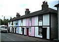
Cottages, Woodfield Lane, Ashtead
At the northern end of Woodfield Lane near Ashtead pond.
Image: © Thomas Grant
Taken: 11 May 2007
0.23 miles