IMAGES TAKEN NEAR TO
The Marld, ASHTEAD, KT21 1RW
Introduction
This page details the photographs taken nearby to The Marld, KT21 1RW by members of the Geograph project.
The Geograph project started in 2005 with the aim of publishing, organising and preserving representative images for every square kilometre of Great Britain, Ireland and the Isle of Man.

There are currently over 7.5m images from over14,400 individuals and you can help contribute to the project by visiting https://www.geograph.org.uk
Image Map
Images are licensed for reuse under creativecommons.org/licenses/by-sa/2.0
Notes
- Clicking on the map will re-center to the selected point.
- The higher the marker number, the further away the image location is from the centre of the postcode.
Image Listing (36 Images Found)
Images are licensed for reuse under creativecommons.org/licenses/by-sa/2.0
Image
Details
Distance
1
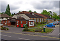
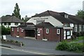
Ashtead Peace Memorial Hall, Woodfield Lane
This is the village hall, which is centrally placed. It has a large main hall with stage, two function rooms, a licensed bar and a resident caretaker. It has charitable status, and is run by a Board of Trustees. Funds were raised for the hall in the early 1920's, and it eventually opened in November 1924. There have been alterations over the years, to meet changing needs.
Image: © P L Chadwick
Taken: 14 Aug 2010
0.09 miles
2
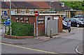
Public convenience, Woodfield Lane
Located just inside the public car park, by Ashtead Peace Memorial Hall.
Image: © P L Chadwick
Taken: 14 Aug 2010
0.10 miles
3
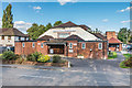
Ashtead Peace Memorial Hall
Community Hall in Woodfield Lane, opened on 3 November 1924.
Image: © Ian Capper
Taken: 7 Sep 2018
0.10 miles
4
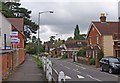
Woodfield Lane
A turning off Ashtead's main road, The Street. In the distance, on the right, is the Ashtead Peace Memorial Hall. Image
Image: © P L Chadwick
Taken: 14 Aug 2010
0.10 miles
5
Ashtead Peace Memorial Hall
Built in 1924 in memory of the armistice. Serves the function of a large village hall.
Image: © Thomas Grant
Taken: 11 May 2007
0.11 miles
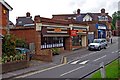
6
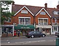
Ashtead Post Office, 39 The Street
The post office is also a newsagents. According to the shop's blind, you can also renew your car tax here. Many of the smaller post offices can't do this, which is a real nuisance. In 2008, the post office was raided, but fortunately the criminals responsible were caught and sent to prison.
Image: © P L Chadwick
Taken: 14 Aug 2010
0.13 miles
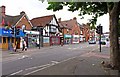
7
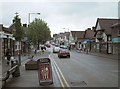
The Street, Ashtead (view NE)
The Street is Ashtead's main thoroughfare and most of the village's shops and services are located here. Traffic is often heavy as it is the route followed by the A24 London to Worthing road. A by-pass to the south of the village was projected in the late 1940s but the plan was ultimately rejected. Looking NE towards Epsom.
Image: © Thomas Grant
Taken: 10 May 2007
0.13 miles
8
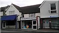
Ashtead Dry Cleaners The Street Ashtead
Image: © PAUL FARMER
Taken: 31 Mar 2012
0.13 miles
9
Superfish, 2 & 4 Woodfield Lane
The local branch of an award winning chain of high quality fish and chip restaurants. Next door, to the right, can be seen the offices of Bailey Financial Limited, a firm of independent financial advisors.
Image: © P L Chadwick
Taken: 14 Aug 2010
0.14 miles
10
The Street (A24)
Ashtead's main shopping and business street.
Image: © P L Chadwick
Taken: 14 Aug 2010
0.14 miles