IMAGES TAKEN NEAR TO
Overdale, ASHTEAD, KT21 1PZ
Introduction
This page details the photographs taken nearby to Overdale, KT21 1PZ by members of the Geograph project.
The Geograph project started in 2005 with the aim of publishing, organising and preserving representative images for every square kilometre of Great Britain, Ireland and the Isle of Man.

There are currently over 7.5m images from over14,400 individuals and you can help contribute to the project by visiting https://www.geograph.org.uk
Image Map
Images are licensed for reuse under creativecommons.org/licenses/by-sa/2.0
Notes
- Clicking on the map will re-center to the selected point.
- The higher the marker number, the further away the image location is from the centre of the postcode.
Image Listing (15 Images Found)
Images are licensed for reuse under creativecommons.org/licenses/by-sa/2.0
Image
Details
Distance
4
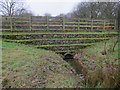
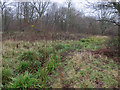
Flow attenuation scheme, The Rye, Ashtead Common
A dam with a half-blocked pipe through it, allowing normal flow along the stream but holding back water in very wet conditions.
Image: © Hugh Venables
Taken: 25 Dec 2015
0.17 miles
5
Flow attenuation scheme, The Rye, Ashtead Common
A dam with a half-blocked pipe through it, allowing normal flow along the stream but holding back water in very wet conditions.
Image: © Hugh Venables
Taken: 25 Dec 2015
0.18 miles
6
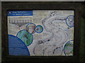
River restoration notice board
By The Rye, on Ashtead Common.
Image: © Hugh Venables
Taken: 25 Dec 2015
0.18 miles
7
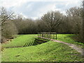
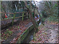
Path over The Rye Brook on Ashtead Common
A path on Ashtead Common, crossing The Rye Brook, which flows beneath through a duct.
This image was taken during the month of February. Trees were bare for the winter season.
Image: © Malc McDonald
Taken: 25 Feb 2023
0.18 miles
8
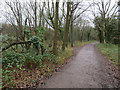
Raised path Ashtead Common
Part of a flow alleviation scheme, see Image
Image: © Hugh Venables
Taken: 25 Dec 2015
0.18 miles
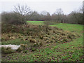
9
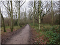
Cycle route along the edge of Newton Wood
Image: © David Martin
Taken: 8 Apr 2022
0.19 miles