IMAGES TAKEN NEAR TO
Overdale, ASHTEAD, KT21 1PU
Introduction
This page details the photographs taken nearby to Overdale, KT21 1PU by members of the Geograph project.
The Geograph project started in 2005 with the aim of publishing, organising and preserving representative images for every square kilometre of Great Britain, Ireland and the Isle of Man.

There are currently over 7.5m images from over14,400 individuals and you can help contribute to the project by visiting https://www.geograph.org.uk
Image Map
Images are licensed for reuse under creativecommons.org/licenses/by-sa/2.0
Notes
- Clicking on the map will re-center to the selected point.
- The higher the marker number, the further away the image location is from the centre of the postcode.
Image Listing (16 Images Found)
Images are licensed for reuse under creativecommons.org/licenses/by-sa/2.0
Image
Details
Distance
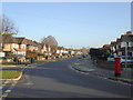
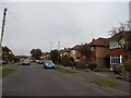
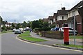
2
Newton Wood Road
The western end of this residential road in Ashtead.
Image: © Ben Gamble
Taken: 9 Jul 2005
0.09 miles
3
Path to Ashtead Common on Newton Wood Road
Image: © David Howard
Taken: 30 Mar 2014
0.11 miles
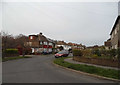
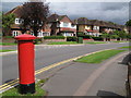
5
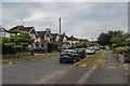
Overdale
Housing built on land previously forming part of Woodfield Farm by the builders E & L Berg in 1935-9.
Image: © Ian Capper
Taken: 20 Jul 2018
0.16 miles
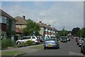
6
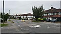
Ashtead - Craddocks Avenue
Residential road near Ashtead Station.
Image: © James Emmans
Taken: 4 Sep 2021
0.16 miles
7
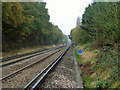
Railway, Ashstead
Looking towards London from the foot crossing between Newton Wood Road to the right and Ashstead Common.
Image: © Robin Webster
Taken: 14 Nov 2011
0.20 miles
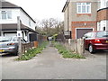
8
Overdale (2)
Image: © Mike Quinn
Taken: 20 Aug 2008
0.21 miles
9
Overdale / Broadhurst
Shows the location of Image
Image: © Mike Quinn
Taken: 20 Aug 2008
0.21 miles