IMAGES TAKEN NEAR TO
Craddocks Avenue, ASHTEAD, KT21 1NX
Introduction
This page details the photographs taken nearby to Craddocks Avenue, KT21 1NX by members of the Geograph project.
The Geograph project started in 2005 with the aim of publishing, organising and preserving representative images for every square kilometre of Great Britain, Ireland and the Isle of Man.

There are currently over 7.5m images from over14,400 individuals and you can help contribute to the project by visiting https://www.geograph.org.uk
Image Map
Images are licensed for reuse under creativecommons.org/licenses/by-sa/2.0
Notes
- Clicking on the map will re-center to the selected point.
- The higher the marker number, the further away the image location is from the centre of the postcode.
Image Listing (15 Images Found)
Images are licensed for reuse under creativecommons.org/licenses/by-sa/2.0
Image
Details
Distance
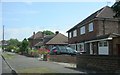
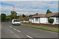
1
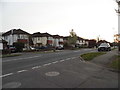
Craddocks Avenue at the junction of Newton Wood Road
Image: © David Howard
Taken: 30 Mar 2014
0.01 miles
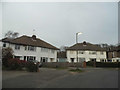
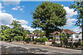
2
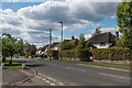
Craddocks Avenue
c1930s housing on Craddocks Avenue.
Image: © Ian Capper
Taken: 7 Sep 2018
0.06 miles
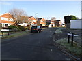
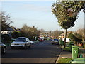
5
Newton Wood Road
The eastern end of this residential road in Ashtead.
Image: © Ben Gamble
Taken: 9 Jul 2005
0.09 miles
6
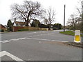
Craddocks avenue at the junction with Epsom Road
Image: © David Howard
Taken: 30 Mar 2014
0.14 miles
7
Art Deco houses on Newton Wood Road
None of them has the original metal windows but the second one has at least copied the style which they all could have.
Image: © David Howard
Taken: 30 Mar 2014
0.16 miles
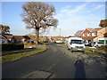
9
Oak Way
Cul de sac on the eastern edge of Ashtead, development of which started in the 1950s.
Image: © Ian Capper
Taken: 28 Apr 2017
0.19 miles
10
Epsom Road
c1930s housing on Epsom Road.
Image: © Ian Capper
Taken: 7 Sep 2018
0.19 miles