IMAGES TAKEN NEAR TO
Cherry Orchard, ASHTEAD, KT21 1HS
Introduction
This page details the photographs taken nearby to Cherry Orchard, KT21 1HS by members of the Geograph project.
The Geograph project started in 2005 with the aim of publishing, organising and preserving representative images for every square kilometre of Great Britain, Ireland and the Isle of Man.

There are currently over 7.5m images from over14,400 individuals and you can help contribute to the project by visiting https://www.geograph.org.uk
Image Map
Images are licensed for reuse under creativecommons.org/licenses/by-sa/2.0
Notes
- Clicking on the map will re-center to the selected point.
- The higher the marker number, the further away the image location is from the centre of the postcode.
Image Listing (18 Images Found)
Images are licensed for reuse under creativecommons.org/licenses/by-sa/2.0
Image
Details
Distance
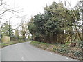
1
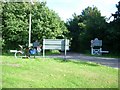
Junction of Wilmerhatch Lane (left), Pleasure Pit Road (right) and Headley Road (ahead)
Image: © Andrew Longton
Taken: 14 Sep 2005
0.08 miles
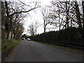
2
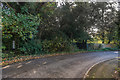
Pleasure Pit Road
Road linking Headley Road and Farm Lane. It was named after Pleasure Pit, a former chalk pit south of its junction with Headley Road - the 1868 1:2500 map marks it as Wilmerhatch Lane, a name which now only applies to the road leading east from its junction with Headley Road. On the left is a Coal Tax Post (no 123 on the list linked to below). For a close up of the post, see Image
Image: © Ian Capper
Taken: 27 Oct 2017
0.08 miles
3
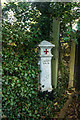
Coal Tax Post no 123
This Coal Tax Post (no 123 on the list linked to below) is situated on Pleasure Pit Road - see Image for wider view. Grade II listed - see www.historicengland.org.uk/listing/the-list/list-entry/1277033.
Image: © Ian Capper
Taken: 27 Oct 2017
0.09 miles
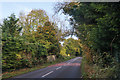
4
Pleasure Pit Road at the junction of Wilmerhatch Road
Image: © David Howard
Taken: 30 Mar 2014
0.10 miles
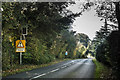
7
Headley Road
Road linking Langley Vale Road with Wilmerhatch Lane, leading on to Epsom.
Image: © Ian Capper
Taken: 27 Oct 2017
0.14 miles
8
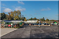
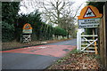
Ashtead Park Garden Centre
Independent garden centre off Pleasure Pit Road.
Image: © Ian Capper
Taken: 27 Oct 2017
0.14 miles
9
Headley Road: racing yards
The gates and 'Accompanied horses or ponies' warning signs alerts road users to the several racing yards located further up Headley Road, with the likelihood that (in the morning) horses will be ridden across the road into Chalk Pit Road, and down the margin of Langley Vale Road to the downs. Just to the left of the left hand sign is a well-hidden alleyway across to Image
Image: © Hugh Craddock
Taken: 26 Dec 2011
0.14 miles
10
Headley Road
Road linking Langley Vale Road with Wilmerhatch Lane, leading on to Epsom.
Image: © Ian Capper
Taken: 27 Oct 2017
0.17 miles