IMAGES TAKEN NEAR TO
Dene Road, ASHTEAD, KT21 1EE
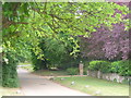
Introduction
This page details the photographs taken nearby to Dene Road, KT21 1EE by members of the Geograph project.
The Geograph project started in 2005 with the aim of publishing, organising and preserving representative images for every square kilometre of Great Britain, Ireland and the Isle of Man.

There are currently over 7.5m images from over14,400 individuals and you can help contribute to the project by visiting https://www.geograph.org.uk
Image Map
Images are licensed for reuse under creativecommons.org/licenses/by-sa/2.0
Notes
- Clicking on the map will re-center to the selected point.
- The higher the marker number, the further away the image location is from the centre of the postcode.
Image Listing (125 Images Found)
Images are licensed for reuse under creativecommons.org/licenses/by-sa/2.0
Image
Details
Distance
1

St Giles C of E School
Primary school in Ashtead, with same name as the parish church. The school was built in 1852, funded by Mary Howard.
Image: © Colin Smith
Taken: 29 May 2011
0.05 miles
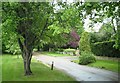
2
Ashtead, Chalk Lane
Upmarket residential area of large detached homes and large gardens below Ashtead Downs.
Image: © Colin Smith
Taken: 29 May 2011
0.13 miles
3
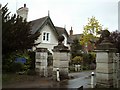
Western gate and gatehouse, Ashtead Park
One of Ashtead Park's three gatehouses.
Image: © Thomas Grant
Taken: 10 May 2007
0.13 miles
4

Rookery Hill, Ashtead
Ornamental gates lead into the Ashtead Park estate which was created in 1680 by the local Lord of the Manor, Sir Richard Howard.
Image: © Colin Smith
Taken: 29 May 2011
0.13 miles
5
Chalk Lane
Private Roads and an upmarket residential area of large homes with large gardens close to Ashtead Downs.
Image: © Colin Smith
Taken: 29 May 2011
0.15 miles
6
Chalk Lane, Ashtead
Very large detached houses predominate in this area of leafy private roads.
Image: © Thomas Grant
Taken: 10 May 2007
0.15 miles
7

Albert Road
Residential street in central Ashtead, running parallel to the main Epsom road.
Image: © Colin Smith
Taken: 29 May 2011
0.16 miles
8
Ashtead Village Club, 104 The Street
A private members' club, situated in the main street of the village.
Image: © P L Chadwick
Taken: 14 Aug 2010
0.16 miles
9
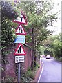
Signs, Rectory Lane, Ashtead
A narrow road, a high brick wall and a busy junction on a blind corner makes the southern end of Rectory Lane awkward to negotiate both in a car and on foot. Despite the numerous problems presented to the driver, this is still a heavily used rat-run, especially during the school run.
Image: © Thomas Grant
Taken: 10 May 2007
0.17 miles
10
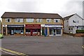
Businesses in The Street
This modern block of shops is occupied by Vanessa Hair Studio, Beijing Palace Chinese Restaurant and Ashtead Computer Services. Next door is Ashtead Village Club; see:- Image
Image: © P L Chadwick
Taken: 14 Aug 2010
0.17 miles