IMAGES TAKEN NEAR TO
Park Lane, ASHTEAD, KT21 1DW
Introduction
This page details the photographs taken nearby to Park Lane, KT21 1DW by members of the Geograph project.
The Geograph project started in 2005 with the aim of publishing, organising and preserving representative images for every square kilometre of Great Britain, Ireland and the Isle of Man.

There are currently over 7.5m images from over14,400 individuals and you can help contribute to the project by visiting https://www.geograph.org.uk
Image Map
Images are licensed for reuse under creativecommons.org/licenses/by-sa/2.0
Notes
- Clicking on the map will re-center to the selected point.
- The higher the marker number, the further away the image location is from the centre of the postcode.
Image Listing (45 Images Found)
Images are licensed for reuse under creativecommons.org/licenses/by-sa/2.0
Image
Details
Distance
1
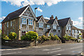
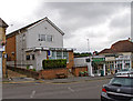
128 - 142 The Street
A group of almshouses at the junction of Park Lane and The Street, named Feilding House after the lady whose legacy in 1733 led to their foundation, Lady Diana Feilding. Originally built to house "6 needy widows", they were altered in 1852 to increase the number of residents to 8 following a donation from Lady Mary Greville Howard of Ashtead Park.
(There seems to be considerable confusion surrounding the spelling of Feilding House, with Fielding House being regularly used in its place, including on the Royal Mail postcode site and various Mole Valley District Council sites. However, it would seem clear that the surname of Lady Diana was indeed Feilding, having married William Feilding in 1705 (who became MP for Castle Rising that year), son of William Feilding, 3rd Earl of Denbigh, the spelling of which would appear to be without doubt.)
Image: © Ian Capper
Taken: 7 Sep 2018
0.05 miles
2
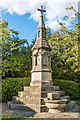
Mary Greville Howard cross and water fountain
Cross and water fountain dating from around 1880, commemorating Mary Greville Howard of Ashtead Park, who had died in 1877. She was the widow of Colonel Fulk Greville Howard, the Howards being significant landowners in Ashtead and benefactors to the village. Grade II listed - see wwwhistoricengland.org.uk/listing/the-list/list-entry/1188512.
Image: © Ian Capper
Taken: 7 Sep 2018
0.06 miles
3
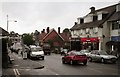
The Street, Ashtead (view SW)
Wet and gloomy day in Ashtead. Looking SW towards the village and Leatherhead.
Image: © Thomas Grant
Taken: 10 May 2007
0.06 miles
4
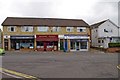
Businesses in The Street
This modern block of shops is occupied by Vanessa Hair Studio, Beijing Palace Chinese Restaurant and Ashtead Computer Services. Next door is Ashtead Village Club; see:- Image
Image: © P L Chadwick
Taken: 14 Aug 2010
0.06 miles
5
Ashtead Village Club, 104 The Street
A private members' club, situated in the main street of the village.
Image: © P L Chadwick
Taken: 14 Aug 2010
0.07 miles
6

St Giles C of E School
Primary school in Ashtead, with same name as the parish church. The school was built in 1852, funded by Mary Howard.
Image: © Colin Smith
Taken: 29 May 2011
0.10 miles
7
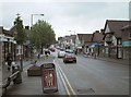
The Street, Ashtead (view NE)
The Street is Ashtead's main thoroughfare and most of the village's shops and services are located here. Traffic is often heavy as it is the route followed by the A24 London to Worthing road. A by-pass to the south of the village was projected in the late 1940s but the plan was ultimately rejected. Looking NE towards Epsom.
Image: © Thomas Grant
Taken: 10 May 2007
0.11 miles
8

Rookery Hill, Ashtead
Ornamental gates lead into the Ashtead Park estate which was created in 1680 by the local Lord of the Manor, Sir Richard Howard.
Image: © Colin Smith
Taken: 29 May 2011
0.11 miles
9
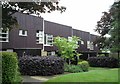
SPAN development, Westfield, Ashtead
Houses in the 1967 "SPAN" estate, Westfield. Designed by architect Eric Lyons. Similar SPAN developments can be found in Weybridge and West Byfleet, Surrey, and New Ash Green, Kent.
Image: © Thomas Grant
Taken: 10 May 2007
0.12 miles
10
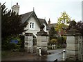
Western gate and gatehouse, Ashtead Park
One of Ashtead Park's three gatehouses.
Image: © Thomas Grant
Taken: 10 May 2007
0.12 miles