IMAGES TAKEN NEAR TO
Meadow Walk, TADWORTH, KT20 7UF
Introduction
This page details the photographs taken nearby to Meadow Walk, KT20 7UF by members of the Geograph project.
The Geograph project started in 2005 with the aim of publishing, organising and preserving representative images for every square kilometre of Great Britain, Ireland and the Isle of Man.

There are currently over 7.5m images from over14,400 individuals and you can help contribute to the project by visiting https://www.geograph.org.uk
Image Map
Images are licensed for reuse under creativecommons.org/licenses/by-sa/2.0
Notes
- Clicking on the map will re-center to the selected point.
- The higher the marker number, the further away the image location is from the centre of the postcode.
Image Listing (115 Images Found)
Images are licensed for reuse under creativecommons.org/licenses/by-sa/2.0
Image
Details
Distance
1
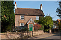
Puplett Cottage
An intriguingly named cottage in Deans Lane.
Image: © Ian Capper
Taken: 24 Mar 2012
0.09 miles
2
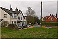
Deans Lane
Victorian cottages on a bend in Deans Lane. In the background is the Riddell Memorial Hall.
Image: © Ian Capper
Taken: 31 Mar 2012
0.11 miles
3
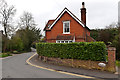
The Rise, Deans Lane
Victorian cottage on a bend in Deans Lane. The dip in the wall in the centre of the photo marks the position of Coal Tax Post no 138 (see Image).
Image: © Ian Capper
Taken: 31 Mar 2012
0.12 miles
4
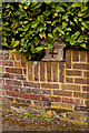
Coal Tax Post no 138
This Coal Tax Post (no 138 on the list linked to below) is in the garden of The Rise in Deans Lane (see Image for wider view), the owners of which have thoughtfully lowered the front wall to enable the top of it to be seen.
Image: © Ian Capper
Taken: 31 Mar 2012
0.12 miles
5

Maurrinder Cottage
This is situated on the corner of Deans Lane, next to Banstead Heath.
Image: © Marathon
Taken: 25 Jun 2014
0.12 miles
6
Nursery Road
A close off Deans Lane. In the background is Chussex, a grade II listed house built in 1908 to a design of Sir Edwin Lutyens. It was built for William Herbert Fowler, who had designed the nearby Walton Heath Golf Course, on which he built up a reputation as one of the best course architects of the period. For listing particulars of the house, see www.historicengland.org.uk/listing/the-list/list-entry/1295187.
Image: © Ian Capper
Taken: 24 Mar 2012
0.12 miles
7
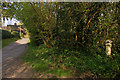
Chuck's Lane
Looking along Chuck's Lane from where it meets Banstead Heath. For close up of the Coal Tax Post on the right, see Image
Image: © Ian Capper
Taken: 24 Apr 2010
0.12 miles
8
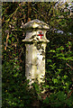
Coal Tax Post no 139
This Coal Tax Post (no 139 on the list linked to below) is at the end of Chuck's Lane where it meets Banstead Heath. See Image for wider view.
Image: © Ian Capper
Taken: 24 Apr 2010
0.12 miles
9
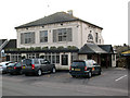
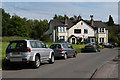
The Blue Ball, Walton-on-the-Hill
The pub is on Deans Lane. The name "blue ball" is a common one, and one suggestion is that it derives from the blue ball that innkeepers hung on a post outside as a signal for stagecoach drivers to stop for passengers. This one is now a 'gastropub' which could be considered the 21st century equivalent of a coaching inn.
Image: © Stephen Craven
Taken: 31 Jan 2010
0.13 miles
10
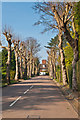
Deans Lane
Road linking the centre of Walton-on-the-Hill with Dorking Road. For another view of the Victorian cottages in the backgrounds, see Image
Image: © Ian Capper
Taken: 8 Jun 2014
0.13 miles