IMAGES TAKEN NEAR TO
New Road, TADWORTH, KT20 7TA
Introduction
This page details the photographs taken nearby to New Road, KT20 7TA by members of the Geograph project.
The Geograph project started in 2005 with the aim of publishing, organising and preserving representative images for every square kilometre of Great Britain, Ireland and the Isle of Man.

There are currently over 7.5m images from over14,400 individuals and you can help contribute to the project by visiting https://www.geograph.org.uk
Image Map
Images are licensed for reuse under creativecommons.org/licenses/by-sa/2.0
Notes
- Clicking on the map will re-center to the selected point.
- The higher the marker number, the further away the image location is from the centre of the postcode.
Image Listing (28 Images Found)
Images are licensed for reuse under creativecommons.org/licenses/by-sa/2.0
Image
Details
Distance
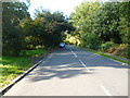
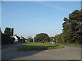
1
Dorking Road at the junction of Mill Road
Image: © David Howard
Taken: 9 Sep 2012
0.05 miles
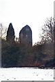
2

Tadworth Windmill
This post windmill stands at the northern end of Banstead Heath. Documentary evidence suggests that this site has carried a mill or mills for more than six centuries. The mill was assisted by a stationary steam engine, before it ceased turning in 1902. It has been hit by 2 bombs, once in 1941 and again in 1944 when it was hit by a flying bomb.
Image: © John Barrett
Taken: 25 May 2005
0.05 miles
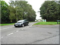
3
Dorking Road, near Tadworth
Dorking Road near Tadworth in Surrey.
Image: © Malc McDonald
Taken: 9 Feb 2019
0.07 miles
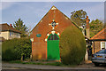
4
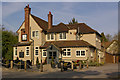
The Blue Anchor
One of three pubs along Dorking Road in Tadworth.
Image: © Ian Capper
Taken: 24 Apr 2010
0.09 miles
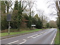
5
Green on Dorking Road, Walton on the Hill
Image: © David Howard
Taken: 22 Sep 2014
0.09 miles
6
Tadworth Green Hall
The plaque gives a building date of 1888, as Kingswood Parish Infants School.
Image: © Ian Capper
Taken: 24 Apr 2010
0.10 miles
7
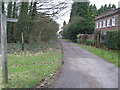
Bridleway leading to Banstead Heath
Image: © Richard Rogerson
Taken: 9 Feb 2011
0.11 miles
8
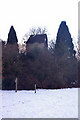
Tadworth Windmill
Late 18th century post mill. Grade II listed - for listing particulars see www.historicengland.org.uk/listing/the-list/list-entry/1377996. The snow cover is from a heavy fall earlier that week.
Image: © Ian Capper
Taken: 7 Feb 2009
0.11 miles
9
Tadworth Windmill
Late 18th century post mill. Grade II listed - for listing particulars see www.historicengland.org.uk/listing/the-list/list-entry/1377996. The snow cover is from a heavy fall earlier that week.
Image: © Ian Capper
Taken: 7 Feb 2009
0.11 miles