IMAGES TAKEN NEAR TO
Sturts Lane, TADWORTH, KT20 7RQ
Introduction
This page details the photographs taken nearby to Sturts Lane, KT20 7RQ by members of the Geograph project.
The Geograph project started in 2005 with the aim of publishing, organising and preserving representative images for every square kilometre of Great Britain, Ireland and the Isle of Man.

There are currently over 7.5m images from over14,400 individuals and you can help contribute to the project by visiting https://www.geograph.org.uk
Image Map
Images are licensed for reuse under creativecommons.org/licenses/by-sa/2.0
Notes
- Clicking on the map will re-center to the selected point.
- The higher the marker number, the further away the image location is from the centre of the postcode.
Image Listing (47 Images Found)
Images are licensed for reuse under creativecommons.org/licenses/by-sa/2.0
Image
Details
Distance
1
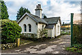
White Lodge
Mid 19th Century former lodge to Frith Park, now separated from the main estate by the M25.
Image: © Ian Capper
Taken: 10 Jan 2020
0.00 miles
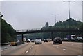
2

White Lodge
Mid 19th Century former lodge to Frith Park, now separated from the main estate by the M25, the bridge carrying Sturt's Lane over which is in the right background of the photo.
Image: © Ian Capper
Taken: 10 Jan 2020
0.01 miles
3
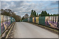
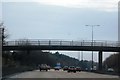
Sturt's Lane M25 bridge
Bridge carrying Sturt's Lane over the M25. The screens are advertising the residential development at Frith Park, for which is the access road.
Image: © Ian Capper
Taken: 10 Jan 2020
0.02 miles
4

Walton-on-the-Hill: The White Lodge
This attractive bungalow stands at the junction of Sturts Lane with Love Lane
Image: © Dr Neil Clifton
Taken: 12 Aug 2013
0.02 miles

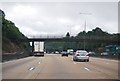

10
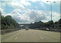
M25 farm-bridge carrying Sturt's Lane
The bridge serves Frith Park Farm.
Image: © Stuart Logan
Taken: 24 Aug 2011
0.03 miles