IMAGES TAKEN NEAR TO
Chequers Lane, TADWORTH, KT20 7RD
Introduction
This page details the photographs taken nearby to Chequers Lane, KT20 7RD by members of the Geograph project.
The Geograph project started in 2005 with the aim of publishing, organising and preserving representative images for every square kilometre of Great Britain, Ireland and the Isle of Man.

There are currently over 7.5m images from over14,400 individuals and you can help contribute to the project by visiting https://www.geograph.org.uk
Image Map
Images are licensed for reuse under creativecommons.org/licenses/by-sa/2.0
Notes
- Clicking on the map will re-center to the selected point.
- The higher the marker number, the further away the image location is from the centre of the postcode.
Image Listing (46 Images Found)
Images are licensed for reuse under creativecommons.org/licenses/by-sa/2.0
Image
Details
Distance
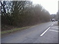
1
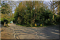
Junction of Sturts Lane and Chequers Lane
In the background is a private hospital, Sturts House Hospital.
Image: © Ian Capper
Taken: 24 Apr 2010
0.04 miles
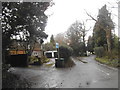
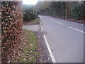
2

Walton-on-the-Hill: Junction of Chequers Lane and Sturts Lane
Sturts Lane is to the left: Chequers Lane continues round to the right
Image: © Dr Neil Clifton
Taken: 12 Aug 2013
0.05 miles
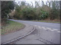
4
Dorking Road at the junction of Chequers Lane
Image: © David Howard
Taken: 20 Nov 2016
0.10 miles
5
Junction of Chequers Lane and Dorking Road
Image: © David Howard
Taken: 20 Feb 2012
0.11 miles
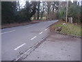
6
Junction of Chequers Lane and Dorking Road
Image: © David Howard
Taken: 20 Feb 2012
0.11 miles
9
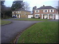
Houses on Fairways, off Chequers Lane
These are neo-Georgian probably built between the 70s and 90s before the design became unfashionable
Image: © David Howard
Taken: 20 Feb 2012
0.13 miles
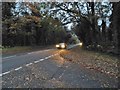
10
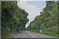
Walton-on-the-Hill : Dorking Road, B2032
Looking along Dorking Road as it heads through Surrey.
Image: © Lewis Clarke
Taken: 8 Aug 2015
0.14 miles