IMAGES TAKEN NEAR TO
Hurst Drive, TADWORTH, KT20 7QT
Introduction
This page details the photographs taken nearby to Hurst Drive, KT20 7QT by members of the Geograph project.
The Geograph project started in 2005 with the aim of publishing, organising and preserving representative images for every square kilometre of Great Britain, Ireland and the Isle of Man.

There are currently over 7.5m images from over14,400 individuals and you can help contribute to the project by visiting https://www.geograph.org.uk
Image Map
Images are licensed for reuse under creativecommons.org/licenses/by-sa/2.0
Notes
- Clicking on the map will re-center to the selected point.
- The higher the marker number, the further away the image location is from the centre of the postcode.
Image Listing (21 Images Found)
Images are licensed for reuse under creativecommons.org/licenses/by-sa/2.0
Image
Details
Distance
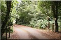
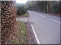
1
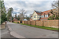
Hurst Drive
Road named after William Hurst Flint, senior partner of surveyors Humbert and Flint, who in 1895 had purchased the area containing Hurst Drive and Heath Drive. Heath Drive was developed first, with the earliest houses in Hurst Drive dating from 1914-15. The house on the right, Roslyn Lodge, is much more recent, having been completed in c2018.
Image: © Ian Capper
Taken: 10 Jan 2020
0.03 miles
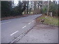
2
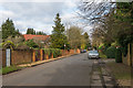
Hurst Drive
Road named after William Hurst Flint, senior partner of surveyors Humbert and Flint, who in 1895 had purchased the area containing Hurst Drive and Heath Drive. Heath Drive was developed first, with the earliest houses in Hurst Drive dating from 1914-15.
Image: © Ian Capper
Taken: 10 Jan 2020
0.05 miles
3
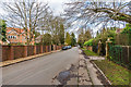
Hurst Drive
Road named after William Hurst Flint, senior partner of surveyors Humbert and Flint, who in 1895 had purchased the area containing Hurst Drive and Heath Drive. Heath Drive was developed first, with the earliest houses in Hurst Drive dating from 1914-15.
Image: © Ian Capper
Taken: 10 Jan 2020
0.07 miles
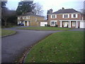
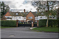
4
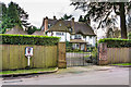
Chequers Corner
House in Hurst Drive, built in 1914 and believed to have been designed by architects Alfred Trehearne and Charles Norman. The first resident was Harry Nuttall, Member of Parliament for Stretford from 1906-18. Hurst Drive itself was named after William Hurst Flint, senior partner of surveyors Humbert and Flint, who had purchased for development the area containing Hurst Drive and Heath Drive in 1895.
Image: © Ian Capper
Taken: 10 Jan 2020
0.09 miles
5
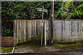
Footpath
Footpath running from Breech Lane towards Walton Heath, crossing various roads en route, the path pre-dating the early 20th Century development of much of the village. This section is the part linking Hurst Drive and Dorking Road. Note the upside down wording on the sign - the other side of the same finger is the right way up, as are both sides of the opposite finger.
Image: © Ian Capper
Taken: 10 Jan 2020
0.10 miles
6
Walton Heath: horse ride and footpath
A horse ride and public footpath Banstead 96 cross over the access drive to Moor Edge and Moor Croft. The ride follows a separate alignment to the footpath, and runs parallel to public footpath Banstead 97: here, it crosses to the opposite side of footpath 96. Barriers discourage equestrian use of the footpath. The woodland (and the access drive) are part of Walton Heath common.
Image: © Hugh Craddock
Taken: 6 Aug 2010
0.10 miles
7
Houses on Fairways, off Chequers Lane
These are neo-Georgian probably built between the 70s and 90s before the design became unfashionable
Image: © David Howard
Taken: 20 Feb 2012
0.12 miles
10
Brackenwood
Development of 10 apartments on Heath Drive, completed in 2013 and built on the site of an earlier house of the same name built in 1925 and designed by Arthur Geen.
Image: © Ian Capper
Taken: 10 Jan 2020
0.15 miles