IMAGES TAKEN NEAR TO
Boxhill Road, TADWORTH, KT20 7PL
Introduction
This page details the photographs taken nearby to Boxhill Road, KT20 7PL by members of the Geograph project.
The Geograph project started in 2005 with the aim of publishing, organising and preserving representative images for every square kilometre of Great Britain, Ireland and the Isle of Man.

There are currently over 7.5m images from over14,400 individuals and you can help contribute to the project by visiting https://www.geograph.org.uk
Image Map (Loading...)


Getting Data...Please wait
Leaflet Map data © OpenStreetMap
Images are licensed for reuse under creativecommons.org/licenses/by-sa/2.0
Notes
- Clicking on the map will re-center to the selected point.
- The higher the marker number, the further away the image location is from the centre of the postcode.
Image Listing (11 Images Found)
Images are licensed for reuse under creativecommons.org/licenses/by-sa/2.0
Image
Details
Distance
1
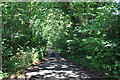
Box Hill: Bridleway off the B2033
The determined rider could probably find her way through to the open land of Headley Heath.
Image: © Dr Neil Clifton
Taken: 9 Aug 2013
0.06 miles
2
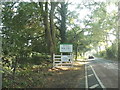
Welcome to Box Hill
On Boxhill Road between Headley and the A24, the only way through.
Image: © David Howard
Taken: 22 Sep 2014
0.12 miles
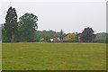
4
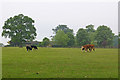
Maybury Farm
A mixed farm of Boxhill Road.
Image: © Ian Capper
Taken: 6 Jun 2010
0.18 miles
5
Maybury Farm
A mixed farm off Boxhill Road.
Image: © Ian Capper
Taken: 6 Jun 2010
0.21 miles
6
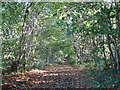
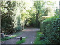
Footpath from Boxhill Road to Station Road
The path here is level and in good condition, however, when it descends steeply down the hill it is very slippery and overgrown.
Image: © don cload
Taken: 8 Oct 2009
0.23 miles

8
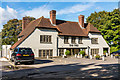
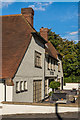
The Tree
Pub on Boxhill Road, previously called the Hand in Hand (see Image).
Image: © Ian Capper
Taken: 10 Oct 2016
0.24 miles
10
The Tree
Pub on Boxhill Road, previously called the Hand in Hand (see Image).
Image: © Ian Capper
Taken: 10 Oct 2016
0.25 miles