IMAGES TAKEN NEAR TO
Boxhill Road, TADWORTH, KT20 7LB
Introduction
This page details the photographs taken nearby to Boxhill Road, KT20 7LB by members of the Geograph project.
The Geograph project started in 2005 with the aim of publishing, organising and preserving representative images for every square kilometre of Great Britain, Ireland and the Isle of Man.

There are currently over 7.5m images from over14,400 individuals and you can help contribute to the project by visiting https://www.geograph.org.uk
Image Map
Images are licensed for reuse under creativecommons.org/licenses/by-sa/2.0
Notes
- Clicking on the map will re-center to the selected point.
- The higher the marker number, the further away the image location is from the centre of the postcode.
Image Listing (136 Images Found)
Images are licensed for reuse under creativecommons.org/licenses/by-sa/2.0
Image
Details
Distance
1

The visitor centre at the top of Box Hill
Image: © Mike Pennington
Taken: 11 Aug 2017
0.01 miles
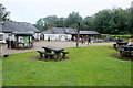
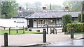
2
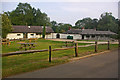
Box Hill shop
The National Trust shop and tea kiosk at the top of Box Hill. Early on a Summer Saturday morning, the area is quiet - later in the day it would have been swarming with people.
Image: © Ian Capper
Taken: 26 Jul 2008
0.01 miles
3
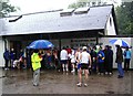
A Wet Day on Box Hill
The runners are waiting to start stage 19 of The Green Belt Relay.
Image: © Sean Davis
Taken: 21 May 2006
0.02 miles
5
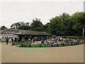
Cyclists atop Box Hill
Since the 2012 Olympic road race came this way, this hill in Surrey has become very popular as a destination with road cyclists, as has the cafe near the summit.
Image: © Stephen Craven
Taken: 5 Oct 2013
0.02 miles
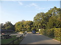
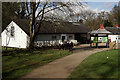
6
Box Hill Visitors Centre and Picnic Area
These visitor facilities lie close to the summit of the hill and just next to the Zig Zag Road. There is a National Trust shop and tea room.
Image: © Nigel Mykura
Taken: 7 Jul 2019
0.02 miles
7
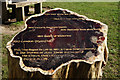
Tree Stump at Box Hill
200 years of history, 1813-2013.
Image: © Peter Trimming
Taken: 9 Mar 2017
0.03 miles
8
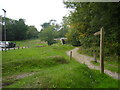
Bridleway to "The Old Fort" at Box Hill
Box Hill Fort was one of 13 Mobilisation Centres built between 1889 and 1903 as part of the London Defence Scheme. They stretched in a line from Epping to Guildford thus protecting London from the possibility of invasion from the Continent (especially France) on its eastern and southern sides. The main purpose of the forts was for the storage of ammunitions to be used by local service personnel in the event of an invasion.
The fort is now a scheduled "Ancient Monument", owned by the National Trust and home to three species of bats who have taken up residence in the old ammunition tunnels. As bats are a protected species the interior of the fort is not open to the public, but you can freely wander around the exterior.
Image: © Sean Davis
Taken: 5 Sep 2010
0.03 miles
9
Box Hill Caf
Close to the summit of Box Hill, and particularly popular in the summer months.
Image: © Peter Trimming
Taken: 9 Mar 2017
0.03 miles
10
Fort Cottages, Box Hill
These cottages used to house the caretaker of the nearby fort. Today they are the visitor centre for the National Trust.
Image: © Hywel Williams
Taken: 13 Oct 2005
0.04 miles