IMAGES TAKEN NEAR TO
Boxhill Road, TADWORTH, KT20 7LA
Introduction
This page details the photographs taken nearby to Boxhill Road, KT20 7LA by members of the Geograph project.
The Geograph project started in 2005 with the aim of publishing, organising and preserving representative images for every square kilometre of Great Britain, Ireland and the Isle of Man.

There are currently over 7.5m images from over14,400 individuals and you can help contribute to the project by visiting https://www.geograph.org.uk
Image Map
Images are licensed for reuse under creativecommons.org/licenses/by-sa/2.0
Notes
- Clicking on the map will re-center to the selected point.
- The higher the marker number, the further away the image location is from the centre of the postcode.
Image Listing (12 Images Found)
Images are licensed for reuse under creativecommons.org/licenses/by-sa/2.0
Image
Details
Distance
1

Olympic Men's Cycle Race
Looking West down towards the Smith & Western restaurant
Image: © Martyn Davies
Taken: 28 Jul 2012
0.13 miles
2
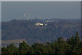
Brockham Warren from Leith Hill
A telephoto shot from the tower on Leith Hill. Brockham Warren, on the North Downs near Box Hill, was built by Mackley Browne in 1816, and was subsequently the home of Sir Benjamin Vincent Sellon Brodie, Bt, the first president of the General Medical Council. In the far distance is Canary Wharf, over 40km away.
Image: © Ian Capper
Taken: 12 Jan 2008
0.17 miles
3
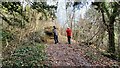
Woodland path on the Brockham Hills
National Trust maintenance crew working hard.
Image: © James Emmans
Taken: 8 Dec 2021
0.17 miles
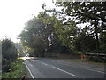
4
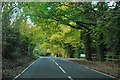
Boxhill Road
The main road through the diffuse settlement of Box Hill.
Image: © Robin Webster
Taken: 1 Nov 2011
0.18 miles
5
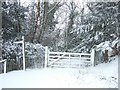
North Downs Way
On a rare snowy day in Surrey. For a picture of the same scene in Summer, see Image
Image: © Martyn Davies
Taken: 8 Feb 2007
0.18 miles
6
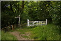
Private!
Through the gate is a track leading to Box Hill Road. But it is private, and so the North Downs Way is diverted down some steps before continuing towards Box Hill summit.
Image: © Ian Capper
Taken: 7 Jun 2008
0.18 miles
7
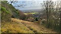
South easterly view from Box Hill
On the southerly escarpment near Oak Wood.
Image: © James Emmans
Taken: 8 Dec 2021
0.18 miles
8
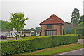
Upper Farm
One of a number of "park home" estates on Boxhill Road. Old photos show Upper Farm originally as a camp site and with an open air swimming pool. The pool is still shown on the 1971 large scale map, situated just off to the left of this photo, with a filling station in front. There is now no sign of either.
Image: © Ian Capper
Taken: 6 Jun 2010
0.18 miles
10
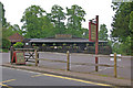
Smith and Western
An American grill/diner on Box Hill. Previous names of the premises were Boxers, the Smugglers Inn, La Collina and the Boxhill Tavern. Even earlier it was the site of the Upper Farm Tea Rooms, before being converted into Wimpy Bar in 1963.
Image: © Ian Capper
Taken: 6 Jun 2010
0.20 miles