IMAGES TAKEN NEAR TO
Roof Of The World Caravan Park, Boxhill Road, TADWORTH, KT20 7JR
Introduction
This page details the photographs taken nearby to Roof Of The World Caravan Park, Boxhill Road, KT20 7JR by members of the Geograph project.
The Geograph project started in 2005 with the aim of publishing, organising and preserving representative images for every square kilometre of Great Britain, Ireland and the Isle of Man.

There are currently over 7.5m images from over14,400 individuals and you can help contribute to the project by visiting https://www.geograph.org.uk
Image Map
Images are licensed for reuse under creativecommons.org/licenses/by-sa/2.0
Notes
- Clicking on the map will re-center to the selected point.
- The higher the marker number, the further away the image location is from the centre of the postcode.
Image Listing (47 Images Found)
Images are licensed for reuse under creativecommons.org/licenses/by-sa/2.0
Image
Details
Distance
1
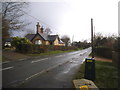
The entrance to Hillcrest at Box Hill village
looking south-east from the north side of Boxhill Road
Image: © Andrew Longton
Taken: 14 Sep 2005
0.05 miles
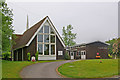
2
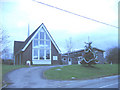
St Andrew's church and hall
This church on the top of Box Hill was originally in the parish of Brockham Green (whose parish church is in the village at the foot of the hill) but was moved in 1971 into Headley parish since the scarp of the North Downs is a physical barrier that isolated it from the former parish.
Image: © Stephen Craven
Taken: 4 Jan 2007
0.07 miles
4

Two single-decker buses at Box Hill
Taken in April 1975, this photo shows two London Country buses in Box Hill Road at the entrance to Greenacres Mobile Home Park. The vehicle on the left is BN45 (GPD 313N) a 1974 Bristol LHS6L with Eastern Coach Works 35-seater bodywork in the National Bus Company Green livery on route 416 to Leatherhead Station. On the right is RF122 (LYF 473) an AEC Regal IV with Metro-Cammell 39-seater bodywork in the Green Line dark and light green livery. Route 416 has been replaced by route 516 between Dorking and Epsom via Box Hill, Headley, Leatherhead and Ashstead, and is now operated by Buses Excetera. The K6 telephone box which can just be seen on the right of the photo has since been replaced by a KX100 phone box.
Image: © David Hillas
Taken: 19 Apr 1975
0.09 miles

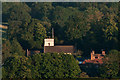
7
St Andrew's Church, Box Hill
The church was built in 1969.
Image: © Ian Capper
Taken: 6 Jun 2010
0.09 miles
8
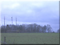
Box Hill Transmitters
Several transmitter stations on the summit of Box Hill. It is an obvious location as on the other side of the wood the land falls sharply and so they can command a wide area including the M25.
Image: © Stephen Craven
Taken: 4 Jan 2007
0.09 miles
9
St Michael's Church, Betchworth
A telephoto view of St Michael's Church, Betchworth (see Image) from the former Betchworth Quarry.
Image: © Ian Capper
Taken: 30 Jun 2012
0.11 miles
10
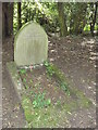
Stone Dead
Grave on the Brockham Hills to "Quick", an "English Thoroughbred" who died in 1944. Quick may have been a dog or a horse.
http://www.surreywildlifetrust.org/reserves/show/25
Image: © Colin Smith
Taken: 29 Jun 2012
0.12 miles