IMAGES TAKEN NEAR TO
Mogador, Lower Kingswood, TADWORTH, KT20 7HS
Introduction
This page details the photographs taken nearby to KT20 7HS by members of the Geograph project.
The Geograph project started in 2005 with the aim of publishing, organising and preserving representative images for every square kilometre of Great Britain, Ireland and the Isle of Man.

There are currently over 7.5m images from over14,400 individuals and you can help contribute to the project by visiting https://www.geograph.org.uk
Image Map
Images are licensed for reuse under creativecommons.org/licenses/by-sa/2.0
Notes
- Clicking on the map will re-center to the selected point.
- The higher the marker number, the further away the image location is from the centre of the postcode.
Image Listing (53 Images Found)
Images are licensed for reuse under creativecommons.org/licenses/by-sa/2.0
Image
Details
Distance
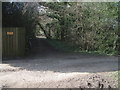
1
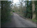
Private Road near Mount Hill
Private road leading to Mogador from Mount Hill.
Image: © John Hilton
Taken: 15 Mar 2007
0.01 miles
2
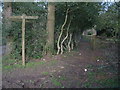
Footpath North from Mount Hill
This footpath running North from Mount Hill leads to Mogador. A private road runs parallel to this path and can just be seen on the left.
Image: © John Hilton
Taken: 15 Mar 2007
0.03 miles
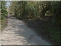
3
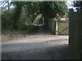
Bridleway East at Mount Hill
Bridleway East at Mount Hill on the North Downs, A private road and footpath to Buckland crosses in the foreground, the track ahead leads to Colley Hill.
Image: © John Hilton
Taken: 15 Mar 2007
0.04 miles
4
View from Mount Hill
Crossing in the foreground is the bridleway route following the ridge of the North Downs. Ahead is Conybury Heights.
Image: © John Hilton
Taken: 15 Mar 2007
0.04 miles
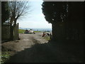
5
Bridleway West at Mount Hill
Bridleway West at Mount Hill on the North Downs. A private road crosses in the foreground.
Image: © John Hilton
Taken: 15 Mar 2007
0.07 miles

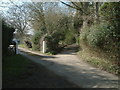
7
Road Junction at Mount Hill
The road on the left is a private road leading to Mogador, the track on the right a bridleway leading to Colley Hill.
Image: © John Hilton
Taken: 15 Mar 2007
0.07 miles
8
Bridleway on the Buckland Hills
A private road crossing the bridleway running along the ridge of the North Downs. The route to the right leading to Thistle Hill.
Image: © John Hilton
Taken: 15 Mar 2007
0.08 miles
9
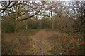
Woodland south of Mogador
Area of woodland northwest of Colley Hill. The tranquil appearance of the scene is misleading: just off the left hand edge of the photo is the M25.
Image: © Ian Capper
Taken: 31 Jan 2009
0.10 miles
