IMAGES TAKEN NEAR TO
Buckland Road, TADWORTH, KT20 7EJ
Introduction
This page details the photographs taken nearby to Buckland Road, KT20 7EJ by members of the Geograph project.
The Geograph project started in 2005 with the aim of publishing, organising and preserving representative images for every square kilometre of Great Britain, Ireland and the Isle of Man.

There are currently over 7.5m images from over14,400 individuals and you can help contribute to the project by visiting https://www.geograph.org.uk
Image Map
Images are licensed for reuse under creativecommons.org/licenses/by-sa/2.0
Notes
- Clicking on the map will re-center to the selected point.
- The higher the marker number, the further away the image location is from the centre of the postcode.
Image Listing (43 Images Found)
Images are licensed for reuse under creativecommons.org/licenses/by-sa/2.0
Image
Details
Distance
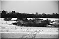
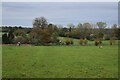
3
Dent's Farm from Mogador Road
View of Dent's Farm from Mogador Road. The TV mast at Reigate Hill can be seen on the skyline to the left, the CAA mast to its right and the water tower at Colley Hill is showing above the trees on the right.
Image: © John Hilton
Taken: 12 Mar 2007
0.04 miles
4
Dent's Farm
Dent's Farm viewed from Margery Wood.
Image: © John Hilton
Taken: 12 Mar 2007
0.04 miles
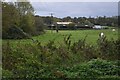
5
Footpath across field near Dent's Farm
Image: © David Martin
Taken: 31 Oct 2022
0.08 miles
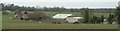
6
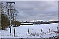
Dent's Farm
Viewed from Mogador Road with Margery Wood in the background. Taken after heavy snow earlier in the week.
Image: © Ian Capper
Taken: 7 Feb 2009
0.09 miles
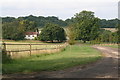
7
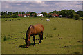
Pasture near Margery Wood
Not unusual land use for this area. The housing in the background is Dents Grove.
Image: © Ian Capper
Taken: 15 Jun 2008
0.11 miles
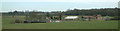
9
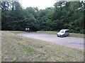
National Trust car park for Queen's Park
This is the National Trust car park for Queen's Park, which is managed by the trust. The park is intersected by the M25 motorway and a special footbridge has been provided to link the park with the car park.
Image: © Hywel Williams
Taken: 18 Jul 2005
0.13 miles
10
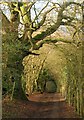
Bridleway, Mogador
BW101 runs towards Mogador along the edge of woodland (left).
Image: © Derek Harper
Taken: 3 Feb 2011
0.15 miles