IMAGES TAKEN NEAR TO
Dents Grove, TADWORTH, KT20 7DX
Introduction
This page details the photographs taken nearby to Dents Grove, KT20 7DX by members of the Geograph project.
The Geograph project started in 2005 with the aim of publishing, organising and preserving representative images for every square kilometre of Great Britain, Ireland and the Isle of Man.

There are currently over 7.5m images from over14,400 individuals and you can help contribute to the project by visiting https://www.geograph.org.uk
Image Map
Images are licensed for reuse under creativecommons.org/licenses/by-sa/2.0
Notes
- Clicking on the map will re-center to the selected point.
- The higher the marker number, the further away the image location is from the centre of the postcode.
Image Listing (38 Images Found)
Images are licensed for reuse under creativecommons.org/licenses/by-sa/2.0
Image
Details
Distance
1
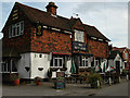
The Mint Arms
It is named after the herb which was grown locally from the end of the 18th century and whose oil went to sweet factories in Mitcham.
A site visitor adds: The Mint Arms has now been demolished to build a small housing estate.
Image: © John Barrett
Taken: 26 May 2005
0.08 miles
2
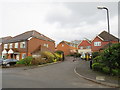
Greenacres, Lower Kingswood
Greenacres is a modern, gated development in the Surrey village of Lower Kingswood.
Image: © Malc McDonald
Taken: 9 Feb 2019
0.08 miles
3
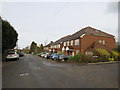
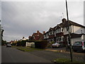
Buckland Road, Lower Kingswood
Buckland Road in the village of Lower Kingswood, near Reigate.
Image: © Malc McDonald
Taken: 9 Feb 2019
0.08 miles
4
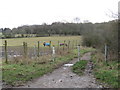
Buckland Road, Lower Kingswood
This track, named Buckland Road. is closed to traffic. However a public right of way exists as a bridleway.
Image: © Malc McDonald
Taken: 9 Feb 2019
0.09 miles
5
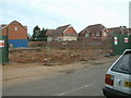
The Mint Arms - Demolished!
This is the site once occupied by the Mint Arms, Lower Kingswood. Now demolished the site is scheduled for housing development.
Image: © John Hilton
Taken: 12 Mar 2007
0.09 miles
6
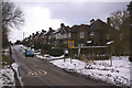
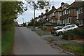
Mogador Road
A ribbon development in what is otherwise open country.
Image: © Ian Capper
Taken: 7 Feb 2009
0.09 miles
7
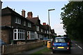
Kingswood: Mogador Road
Looking west
Image: © Dr Neil Clifton
Taken: 26 Aug 2013
0.09 miles
10
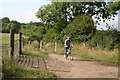
Mogador: Buckland Road
The southern part of Buckland Road is not passable by motor vehicles, and is only a bridleway, from which a cyclist is seen here emerging.
Image: © Dr Neil Clifton
Taken: 26 Aug 2013
0.11 miles