IMAGES TAKEN NEAR TO
Buckland Road, TADWORTH, KT20 7DN
Introduction
This page details the photographs taken nearby to Buckland Road, KT20 7DN by members of the Geograph project.
The Geograph project started in 2005 with the aim of publishing, organising and preserving representative images for every square kilometre of Great Britain, Ireland and the Isle of Man.

There are currently over 7.5m images from over14,400 individuals and you can help contribute to the project by visiting https://www.geograph.org.uk
Image Map
Images are licensed for reuse under creativecommons.org/licenses/by-sa/2.0
Notes
- Clicking on the map will re-center to the selected point.
- The higher the marker number, the further away the image location is from the centre of the postcode.
Image Listing (64 Images Found)
Images are licensed for reuse under creativecommons.org/licenses/by-sa/2.0
Image
Details
Distance
1

Kingswood Primary School
Situated on Buckland Road.
Image: © Ian Capper
Taken: 18 Aug 2012
0.02 miles
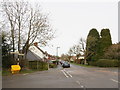
2
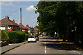
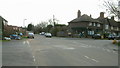
Buckland Road, Lower Kingswood, Surrey
Buckland Road leads towards the A217, and the centre of Lower Kingswood. Note the distant 20mph speed limit, and school, signs.
Image: © Peter Trimming
Taken: 24 May 2011
0.07 miles
3
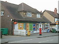
Lower Kingswood Sub Post Office and Shop
The Sub Post Office and Shop in Buckland Road, Lower Kingswood.
Image: © John Hilton
Taken: 12 Mar 2007
0.11 miles
4
Stubbs Lane, Lower Kingswood
Stubbs Lane, Lower Kingswood pictured from Mogador Road at the junction with Buckland Road.
Image: © John Hilton
Taken: 12 Mar 2007
0.13 miles
5
Stubbs Lane, Lower Kingswood, Surrey
Stubbs Lane leads through to the busy A217, and bounds the old Kingswood Manor estate.
Image: © Peter Trimming
Taken: 24 May 2011
0.13 miles
6
Buckland Road junction with Mogador Road
View, looking South, of the Buckland Road junction with Mogador Road (right) and Stubbs Lane (left).
Image: © John Hilton
Taken: 12 Mar 2007
0.13 miles
7
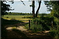
Public Bridleway at Lower Kingswood, Surrey
This bridleway (to the right of picture) leads from Lower Kingswood, across Banstead Heath, to Walton on the Hill.
Image: © Peter Trimming
Taken: 24 May 2011
0.13 miles
8
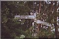
Old Direction Sign - Signpost by Mogador Road, Kingswood Parish
Lost finial - 3 arms; Surrey post by the UC road, in parish of Kingswood (Reigate and Banstead District), Mogador Road, junction with Buckland Road and bridle path, on verge.
Surveyed
Milestone Society National ID: SY_TQ2453
Image: © Milestone Society
Taken: 17 Sep 2009
0.14 miles
9
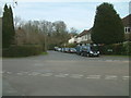
Crossroads of Buckland Road, Church Close and Josephine Avenue
Image: © Basher Eyre
Taken: 15 Feb 2018
0.14 miles
10
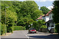
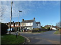
Buckland Road, Lower Kingswood
Buckland Road in the village of Lower Kingswood, at the junction with Stubbs Lane and Mogador Road. A traditional direction signpost survuves, behind the yellow bin to the left of the image.
Image: © Malc McDonald
Taken: 9 Feb 2019
0.14 miles