IMAGES TAKEN NEAR TO
Margery Wood Lane, TADWORTH, KT20 7BA
Introduction
This page details the photographs taken nearby to Margery Wood Lane, KT20 7BA by members of the Geograph project.
The Geograph project started in 2005 with the aim of publishing, organising and preserving representative images for every square kilometre of Great Britain, Ireland and the Isle of Man.

There are currently over 7.5m images from over14,400 individuals and you can help contribute to the project by visiting https://www.geograph.org.uk
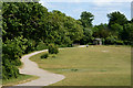
Image Map
Images are licensed for reuse under creativecommons.org/licenses/by-sa/2.0
Notes
- Clicking on the map will re-center to the selected point.
- The higher the marker number, the further away the image location is from the centre of the postcode.
Image Listing (197 Images Found)
Images are licensed for reuse under creativecommons.org/licenses/by-sa/2.0
Image
Details
Distance
1
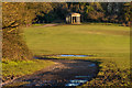
View Towards the Inglis Memorial, Colley Hill, Surrey
Seen from the North Downs Way; the memorial stands in the adjacent grid square.
Image: © Peter Trimming
Taken: 24 May 2011
0.08 miles
2
Waymarks on Colley Hill
Pilgrim characters on the waymarks on top of Colley Hill, near Reigate.
Image: © Colin Smith
Taken: 10 Jul 2011
0.09 miles
3
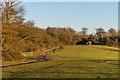
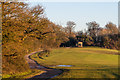
Colley Hill
Looking along Colley Hill, with the Inglis Memorial in the background. The track forms part of the North Downs Way long distance footpath.
Image: © Ian Capper
Taken: 15 Jan 2016
0.10 miles
4
Colley Hill
Looking along Colley Hill, with the Inglis Memorial in the background. The track forms part of the North Downs Way long distance footpath.
Image: © Ian Capper
Taken: 15 Jan 2016
0.10 miles
5
Colley Hill
Looking along Colley Hill, with the Inglis Memorial in the background. The track forms part of the North Downs Way long distance footpath.
Image: © Ian Capper
Taken: 15 Jan 2016
0.10 miles
6
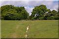
Path on Colley Hill
A section of one of the medieval routes out of Reigate over the North Downs, where it crosses Colley Hill. The gate leads on to Margery Wood Lane, with the route then leading on towards Walton Heath.
Image: © Ian Capper
Taken: 17 May 2009
0.10 miles
7
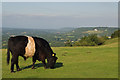
Beltie on Colley Hill
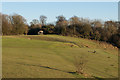
One of a small herd of Belted Galloway cattle on Colley Hill, used to maintain the downland grass. In the background is the continuation of the North Downs, with the former Betchworth Quarry prominent on the right. In the centre background can just be seen the town of Dorking with the spire of St Martin's church visible.
Image: © Ian Capper
Taken: 30 Jul 2011
0.11 miles
8
Crater, Colley Hill
Although initial thoughts might be that this is a bomb crater or a crash site, apparently it is a natural dip.
Image: © Ian Capper
Taken: 17 May 2009
0.11 miles
9
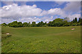
Colley Hill
Looking along Colley Hill, with the Inglis Memorial in the background. Crossing from left to right is the bridleway, once one of the medieval routes out of Reigate over the North Downs, leading on to Walton Heath.
Image: © Ian Capper
Taken: 15 Jan 2016
0.11 miles
10
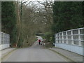
Lane leading to Colley Hill
Lane leading to Colley Hill from Margery Road, viewed South from bridge over the M25.
Image: © John Hilton
Taken: 12 Mar 2007
0.11 miles