IMAGES TAKEN NEAR TO
Orchard Way, TADWORTH, KT20 7AD
Introduction
This page details the photographs taken nearby to Orchard Way, KT20 7AD by members of the Geograph project.
The Geograph project started in 2005 with the aim of publishing, organising and preserving representative images for every square kilometre of Great Britain, Ireland and the Isle of Man.

There are currently over 7.5m images from over14,400 individuals and you can help contribute to the project by visiting https://www.geograph.org.uk
Image Map
Images are licensed for reuse under creativecommons.org/licenses/by-sa/2.0
Notes
- Clicking on the map will re-center to the selected point.
- The higher the marker number, the further away the image location is from the centre of the postcode.
Image Listing (18 Images Found)
Images are licensed for reuse under creativecommons.org/licenses/by-sa/2.0
Image
Details
Distance
1
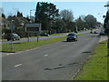
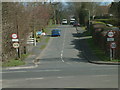
A217 Lower Kingswood
View looking South from Green Lane junction towards Lower Kingswood Village.
Image: © John Hilton
Taken: 11 Mar 2007
0.13 miles
3
Caravan Park
This site is listed as a Caravan Park on the Ordnance Survey map and is a small estate of semi-permanent residential caravans.
Image: © Hywel Williams
Taken: 14 Jun 2005
0.15 miles
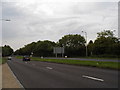
4
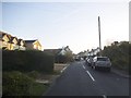
Brighton Road, Lower Kingswood
View of the A217 Brighton Road looking North to Sutton from the Buckland Road junction. The pedestrian crossing is pictured in the foreground.
Image: © John Hilton
Taken: 12 Mar 2007
0.17 miles
5
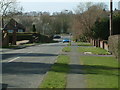
Green Lane, Lower Kingswood
Green Lane, Lower Kingswood viewed from its junction with the A217 Brighton Road.
Image: © John Hilton
Taken: 11 Mar 2007
0.19 miles
6
Green Lane, Lower Kingswood
Green Lane, Lower Kingswood looking West towards the junction with the A217 Brighton Road.
Image: © John Hilton
Taken: 11 Mar 2007
0.20 miles
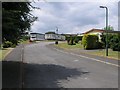
7
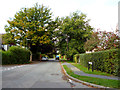
Smithy Lane, Lower Kingswood
The houses on the far left replaced a single bungalow some time since 2012
Image: © David Howard
Taken: 1 Nov 2015
0.20 miles
8
Lower Kingswood: Green Lane
Looking west down the western end of Green Lane, from the Smithy Lane junction
Image: © Dr Neil Clifton
Taken: 6 Oct 2013
0.23 miles
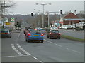
9
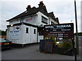
Royal Gurkha @ The Fox on the Hill
Maybe not your traditional pub grub, but handy for a cool drink.
Image: © Ian Paterson
Taken: 15 Jul 2015
0.23 miles
10
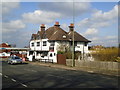
The Fox on the Hill, Lower Kingswood
Image: © Stacey Harris
Taken: 18 Mar 2012
0.24 miles