IMAGES TAKEN NEAR TO
Brier Lea, TADWORTH, KT20 6TR
Introduction
This page details the photographs taken nearby to Brier Lea, KT20 6TR by members of the Geograph project.
The Geograph project started in 2005 with the aim of publishing, organising and preserving representative images for every square kilometre of Great Britain, Ireland and the Isle of Man.

There are currently over 7.5m images from over14,400 individuals and you can help contribute to the project by visiting https://www.geograph.org.uk
Image Map
Images are licensed for reuse under creativecommons.org/licenses/by-sa/2.0
Notes
- Clicking on the map will re-center to the selected point.
- The higher the marker number, the further away the image location is from the centre of the postcode.
Image Listing (24 Images Found)
Images are licensed for reuse under creativecommons.org/licenses/by-sa/2.0
Image
Details
Distance
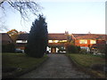
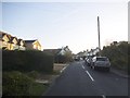
2
Green Lane, Lower Kingswood
Green Lane, Lower Kingswood at the junction of Smithy Lane (left) and the Fidelity Investments entrance (right).
Image: © John Hilton
Taken: 11 Mar 2007
0.08 miles
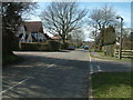
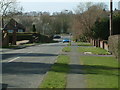
4
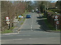
Lower Kingswood: Green Lane
Looking west down the western end of Green Lane, from the Smithy Lane junction
Image: © Dr Neil Clifton
Taken: 6 Oct 2013
0.09 miles
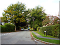
5
Smithy Lane, Lower Kingswood
The houses on the far left replaced a single bungalow some time since 2012
Image: © David Howard
Taken: 1 Nov 2015
0.11 miles
6
Green Lane, Lower Kingswood
Green Lane, Lower Kingswood viewed from Grub Wood.
Image: © John Hilton
Taken: 11 Mar 2007
0.13 miles
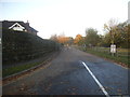
7
Green Lane, Lower Kingswood
Green Lane, Lower Kingswood looking West towards the junction with the A217 Brighton Road.
Image: © John Hilton
Taken: 11 Mar 2007
0.13 miles
8
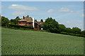
On the Edge of the Countryside
The house, across the field, is at the northern limit of Lower Kingswood, Surrey.
Image: © Peter Trimming
Taken: 24 May 2011
0.14 miles
9
Green Lane, Lower Kingswood
Green Lane, Lower Kingswood viewed from its junction with the A217 Brighton Road.
Image: © John Hilton
Taken: 11 Mar 2007
0.15 miles
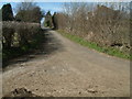
10
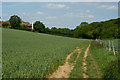
Public Bridleway at Kingswood, Surrey
Looking in the direction of Mugswell.
Image: © Peter Trimming
Taken: 24 May 2011
0.15 miles