IMAGES TAKEN NEAR TO
Brighton Road, TADWORTH, KT20 6SB
Introduction
This page details the photographs taken nearby to Brighton Road, KT20 6SB by members of the Geograph project.
The Geograph project started in 2005 with the aim of publishing, organising and preserving representative images for every square kilometre of Great Britain, Ireland and the Isle of Man.

There are currently over 7.5m images from over14,400 individuals and you can help contribute to the project by visiting https://www.geograph.org.uk
Image Map
Images are licensed for reuse under creativecommons.org/licenses/by-sa/2.0
Notes
- Clicking on the map will re-center to the selected point.
- The higher the marker number, the further away the image location is from the centre of the postcode.
Image Listing (24 Images Found)
Images are licensed for reuse under creativecommons.org/licenses/by-sa/2.0
Image
Details
Distance
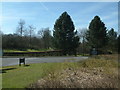
1
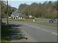
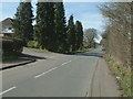
Chipstead Lane Roundabout looking North
Chipstead Lane Roundabout on the A217 Brighton Road, looking North towards Kingswood.
Image: © John Hilton
Taken: 11 Mar 2007
0.04 miles
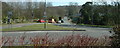
2
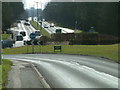
Chipstead Lane Roundabout looking South
View of Chipstead Lane Roundabout looking South towards Lower Kingswood Village.
Image: © John Hilton
Taken: 11 Mar 2007
0.04 miles
3
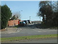
Beechen Lane, Lower Kingswood
The junction of Beechen Lane, Lower Kingswood with the A217 Brighton Road.
Image: © John Hilton
Taken: 11 Mar 2007
0.05 miles
5
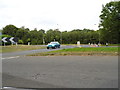
Red Lodge Entrance
View of the Red Lodge Entrance from the Chipstead Lane roundabout.
Image: © John Hilton
Taken: 11 Mar 2007
0.06 miles
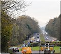
6
Chipstead Lane from the roundabout on the A217
View, looking East, of Chipstead Lane taken from the roundabout on the A217, Brighton Road.
Image: © John Hilton
Taken: 11 Mar 2007
0.06 miles
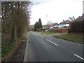
9
Chipstead Lane, Lower Kingswood
View of Chipstead Lane, Lower Kingswood looking West to the roundabout on the A217 Brighton Road. The junction with Beechen Lane is seen on the left.
Image: © John Hilton
Taken: 11 Mar 2007
0.11 miles
10
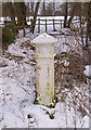
Coal Tax Post no 154
This plain Coal Tax Post (no 154 on the list linked to below) (most of the others have the crest and other details painted) is on the edge of Banstead Heath, at the end of a short path running down from the Chipstead Lane roundabout on the A217. See Image for context. Grade II listed - for listing particulars see www.historicengland.org.uk/listing/the-list/list-entry/1240328.
Image: © Ian Capper
Taken: 7 Feb 2009
0.12 miles