IMAGES TAKEN NEAR TO
Heather Close, TADWORTH, KT20 6NY
Introduction
This page details the photographs taken nearby to Heather Close, KT20 6NY by members of the Geograph project.
The Geograph project started in 2005 with the aim of publishing, organising and preserving representative images for every square kilometre of Great Britain, Ireland and the Isle of Man.

There are currently over 7.5m images from over14,400 individuals and you can help contribute to the project by visiting https://www.geograph.org.uk
Image Map
Images are licensed for reuse under creativecommons.org/licenses/by-sa/2.0
Notes
- Clicking on the map will re-center to the selected point.
- The higher the marker number, the further away the image location is from the centre of the postcode.
Image Listing (13 Images Found)
Images are licensed for reuse under creativecommons.org/licenses/by-sa/2.0
Image
Details
Distance
1
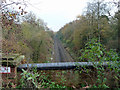
Tattenham Corner Branch, east of Kingswood Tunnel
Viewed from above the tunnel mouth, which is beside the A217.
Image: © Robin Webster
Taken: 22 Nov 2010
0.05 miles
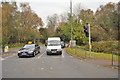
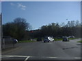
2
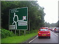
Brighton Road approaching the Tadworth roundabout
Image: © David Howard
Taken: 16 Jul 2012
0.12 miles
3
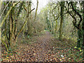
Path, Banstead Heath
Towards and across Bonsor Drive.
Image: © Robin Webster
Taken: 22 Nov 2010
0.12 miles
4
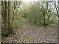
Path, Banstead Heath
The heath here is largely woodland.
Image: © Robin Webster
Taken: 22 Nov 2010
0.13 miles
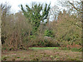
6
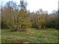
Woodland clearing, common land
This seems to be Banstead Heath, it is conjoined with Burgh Heath.
Image: © Robin Webster
Taken: 22 Nov 2010
0.15 miles
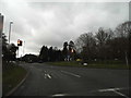
8
Bonsor Drive at the junction of Brighton Road
Image: © David Howard
Taken: 16 Jul 2012
0.16 miles
10
Banstead Heath
Largely woodland in this part.
Image: © Robin Webster
Taken: 22 Nov 2010
0.18 miles