IMAGES TAKEN NEAR TO
Forest Drive, TADWORTH, KT20 6LU
Introduction
This page details the photographs taken nearby to Forest Drive, KT20 6LU by members of the Geograph project.
The Geograph project started in 2005 with the aim of publishing, organising and preserving representative images for every square kilometre of Great Britain, Ireland and the Isle of Man.

There are currently over 7.5m images from over14,400 individuals and you can help contribute to the project by visiting https://www.geograph.org.uk
Image Map
Images are licensed for reuse under creativecommons.org/licenses/by-sa/2.0
Notes
- Clicking on the map will re-center to the selected point.
- The higher the marker number, the further away the image location is from the centre of the postcode.
Image Listing (21 Images Found)
Images are licensed for reuse under creativecommons.org/licenses/by-sa/2.0
Image
Details
Distance
1
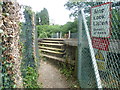
Approach to foot crossing over the railway
A branch line along the Chipstead Valley from the Brighton Main Line was first projected in 1884. This scheme failed to take off. The line from Purley East Junction to Kingswood & Burgh Heath was eventually opened on 2nd November 1897 as a single track and this was doubled during 1899. The line finally reached Tattenham Corner on 4th June 1901 - Derby Day. The railway provides attractive views of Chipstead Valley and it is certainly one of the pleasantest rides within London Travelcard Zone 6, even though most of it is in Surrey.
This foot crossing passes around the back gardens of houses in Forest Drive and then up the driveway of one to reach Forest Drive.
Image: © Marathon
Taken: 14 Aug 2013
0.05 miles
2
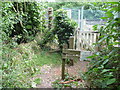
Approach to railway foot crossing
A branch line along the Chipstead Valley from the Brighton Main Line was first projected in 1884. This scheme failed to take off. The line from Purley East Junction to Kingswood & Burgh Heath was eventually opened on 2nd November 1897 as a single track and this was doubled during 1899. The line finally reached Tattenham Corner on 4th June 1901 - Derby Day. The railway provides attractive views of Chipstead Valley and it is certainly one of the pleasantest rides within London Travelcard Zone 6, even though most of it is in Surrey.
This foot crossing passes around the back gardens of houses in Forest Drive and then up the driveway of one to reach Forest Drive.
Image: © Marathon
Taken: 14 Aug 2013
0.06 miles
3
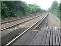
View from foot crossing near Kingswood
A branch line along the Chipstead Valley from the Brighton Main Line was first projected in 1884. This scheme failed to take off. The line from Purley East Junction to Kingswood & Burgh Heath was eventually opened on 2nd November 1897 as a single track and this was doubled during 1899. The line finally reached Tattenham Corner on 4th June 1901 - Derby Day. The railway provides attractive views of Chipstead Valley and it is certainly one of the pleasantest rides within London Travelcard Zone 6, even though most of it is in Surrey.
This foot crossing passes around the back gardens of houses in Forest Drive and then up the driveway of one to reach Forest Drive. This view looks down the line towards Kingswood station.
Image: © Marathon
Taken: 14 Aug 2013
0.07 miles
4
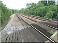
View from foot crossing near Kingswood
A branch line along the Chipstead Valley from the Brighton Main Line was first projected in 1884. This scheme failed to take off. The line from Purley East Junction to Kingswood & Burgh Heath was eventually opened on 2nd November 1897 as a single track and this was doubled during 1899. The line finally reached Tattenham Corner on 4th June 1901 - Derby Day. The railway provides attractive views of Chipstead Valley and it is certainly one of the pleasantest rides within London Travelcard Zone 6, even though most of it is in Surrey.
This foot crossing passes around the back gardens of houses in Forest Drive and then up the driveway of one to reach Forest Drive. This view looks up the line. The next station in this direction is Chipstead.
Image: © Marathon
Taken: 14 Aug 2013
0.10 miles
5
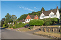
Forest Drive
Private road in Kingswood, this section developed in the c1920s.
Image: © Ian Capper
Taken: 5 Aug 2018
0.14 miles
6
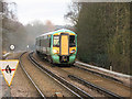
Electrostar at Kingswood
One of the newer trains operating the Tattenham Corner branch line on a Sunday afternoon. The sign in the foreground presumably warns drivers of the risk of slipping on wet leaves when leaving the station. Beyond that the "W" sign indicates to Whistle (hoot) because there is a footpath crossing the line just round the bend at TQ252568.
Image: © Stephen Craven
Taken: 31 Jan 2010
0.18 miles
7
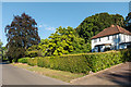
Forest Drive
Private road in Kingswood, this section developed in the c1920s.
Image: © Ian Capper
Taken: 5 Aug 2018
0.20 miles
8

Kingswood : Legal and General House
Former HQ building of the Legal and General Assurance Company : awaiting redevelopment. Grade II* listed - see this https://historicengland.org.uk/listing/the-list/list-entry/1451212?section=official-list-entry. Built between 1986 and 1991 to a design by Arup Associates
Image: © Jim Osley
Taken: 1 Jul 2024
0.21 miles
9

Kingswood : Legal and General House
Former HQ building of the Legal and General Assurance Company : awaiting redevelopment. Grade II* listed - see this https://historicengland.org.uk/listing/the-list/list-entry/1451212?section=official-list-entry. Built between 1986 and 1991 to a design by Arup Associates
Image: © Jim Osley
Taken: 1 Jul 2024
0.21 miles
10

Kingswood : Legal and General House
Former HQ building of the Legal and General Assurance Company : awaiting redevelopment. Grade II* listed - see this https://historicengland.org.uk/listing/the-list/list-entry/1451212?section=official-list-entry. Built between 1986 and 1991 to a design by Arup Associates
Image: © Jim Osley
Taken: 1 Jul 2024
0.21 miles