IMAGES TAKEN NEAR TO
Eyhurst Park, Outwood Lane, TADWORTH, KT20 6JR
Introduction
This page details the photographs taken nearby to Eyhurst Park, Outwood Lane, KT20 6JR by members of the Geograph project.
The Geograph project started in 2005 with the aim of publishing, organising and preserving representative images for every square kilometre of Great Britain, Ireland and the Isle of Man.

There are currently over 7.5m images from over14,400 individuals and you can help contribute to the project by visiting https://www.geograph.org.uk
Image Map
Images are licensed for reuse under creativecommons.org/licenses/by-sa/2.0
Notes
- Clicking on the map will re-center to the selected point.
- The higher the marker number, the further away the image location is from the centre of the postcode.
Image Listing (5 Images Found)
Images are licensed for reuse under creativecommons.org/licenses/by-sa/2.0
Image
Details
Distance
1
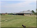
The 19th Hole
The 19th Hole of Surrey Downs Golf Club
Image: © Hywel Williams
Taken: 22 Jun 2005
0.05 miles
2
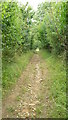
Footpath Near Chipstead
Footpath gently climbs out of the valley, towards Eyhurst Park.
Image: © Peter Trimming
Taken: 4 Aug 2008
0.18 miles
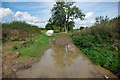
3

The winding way, Surrey Downs golf course
There were few people on the golf course this afternoon. After a rather wet period, the weather was improving as the day went on.
Image: © Robin Webster
Taken: 6 Oct 2010
0.22 miles
4
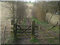
Bridleway to Eyhurst Farm
Bridleway to Eyhurst Farm at its junction with White Hill and Southerns Lane.
Image: © John Hilton
Taken: 12 Mar 2007
0.24 miles
5
Navigable bridleway?
No, the boat is for navigating a pond forming a hazard for the Surrey Downs 9th and 18th holes over to the left.
Image: © Robin Webster
Taken: 6 Oct 2010
0.25 miles