IMAGES TAKEN NEAR TO
The Chase, TADWORTH, KT20 6HY
Introduction
This page details the photographs taken nearby to The Chase, KT20 6HY by members of the Geograph project.
The Geograph project started in 2005 with the aim of publishing, organising and preserving representative images for every square kilometre of Great Britain, Ireland and the Isle of Man.

There are currently over 7.5m images from over14,400 individuals and you can help contribute to the project by visiting https://www.geograph.org.uk
Image Map
Images are licensed for reuse under creativecommons.org/licenses/by-sa/2.0
Notes
- Clicking on the map will re-center to the selected point.
- The higher the marker number, the further away the image location is from the centre of the postcode.
Image Listing (11 Images Found)
Images are licensed for reuse under creativecommons.org/licenses/by-sa/2.0
Image
Details
Distance
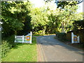
1
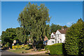
The Glade
Private road in Kingswood, this section developed in the c1920s.
Image: © Ian Capper
Taken: 5 Aug 2018
0.07 miles
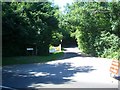
3
Glade Spur
Looking up this short dead-end turning off The Glade.
Image: © Robin Webster
Taken: 6 Oct 2010
0.11 miles
4
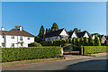
The Glade
Private road in Kingswood, this section developed in the c1920s.
Image: © Ian Capper
Taken: 5 Aug 2018
0.11 miles
5
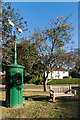
Electricity transformer pillar
Electricity transformer pillar situated in a grass triangle at the junction of Forest Drive and The Glade, two private roads development of which started around 1914 although largely carried out in the c1920s. The transformer pillar was installed in 1914 as a part of this development (although the streetlight is a late 20th Century replacement) and is grade II listed - see www.historicengland.org.uk/listing/the-list/list-entry/1396381.
Image: © Ian Capper
Taken: 5 Aug 2018
0.11 miles
7
Outwood Lane: The Glade
Private road into a very top-end estate
Image: © Dr Neil Clifton
Taken: 8 Oct 2013
0.16 miles
8
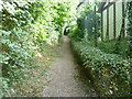
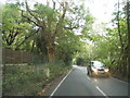
Footpath on the edge of Kingswood
This footpath passes between Chiphouse Wood and Kingswood. It then crosses Forest Drive and The Chase before reaching Outwood Lane. On the right are the fences of houses in Drive Spur. Chiphouse Wood is on the left.
Image: © Marathon
Taken: 14 Aug 2013
0.20 miles
9
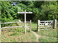
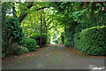
Entrance to Chiphouse Wood
This is on the edge of Kingswood. The footpath ahead passes through the main part of Chiphouse Wood and eventually reaches Outwood Lane. Chiphouse Wood is owned by the Woodland Trust. See http://www.woodlandtrust.org.uk/en/our-woods/Pages/wood-details.aspx?wood=4099#.UhvGLxusiSo for more information about Chiphouse Wood.
Image: © Marathon
Taken: 14 Aug 2013
0.24 miles
10
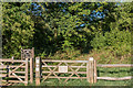
Chiphouse Wood
Entrance into the Woodland Trust's Chiphouse Wood.
Image: © Ian Capper
Taken: 5 Aug 2018
0.24 miles