IMAGES TAKEN NEAR TO
Somerfield Close, TADWORTH, KT20 6DB
Introduction
This page details the photographs taken nearby to Somerfield Close, KT20 6DB by members of the Geograph project.
The Geograph project started in 2005 with the aim of publishing, organising and preserving representative images for every square kilometre of Great Britain, Ireland and the Isle of Man.

There are currently over 7.5m images from over14,400 individuals and you can help contribute to the project by visiting https://www.geograph.org.uk
Image Map
Images are licensed for reuse under creativecommons.org/licenses/by-sa/2.0
Notes
- Clicking on the map will re-center to the selected point.
- The higher the marker number, the further away the image location is from the centre of the postcode.
Image Listing (24 Images Found)
Images are licensed for reuse under creativecommons.org/licenses/by-sa/2.0
Image
Details
Distance
1
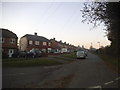
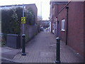
Modernist housing
Ballards Green, Burgh Heath
Image: © David Howard
Taken: 28 Dec 2009
0.06 miles
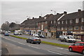
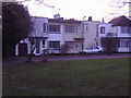
2
Ballards Green
1930s housing estate round the green.
Image: © David Howard
Taken: 28 Dec 2009
0.07 miles
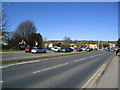
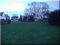
3
Ballards Green
Modernist 1930s housing estate round the green
Image: © David Howard
Taken: 28 Dec 2009
0.08 miles
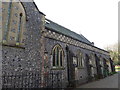
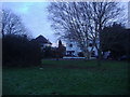
4
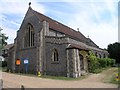
St Mary's Church
St Mary's Church, just making it into the northern edge of this square. The church stands on the side of the busy A217 dual carriageway.
Image: © Hywel Williams
Taken: 22 Jun 2005
0.08 miles