IMAGES TAKEN NEAR TO
Oatlands Road, TADWORTH, KT20 6BS
Introduction
This page details the photographs taken nearby to Oatlands Road, KT20 6BS by members of the Geograph project.
The Geograph project started in 2005 with the aim of publishing, organising and preserving representative images for every square kilometre of Great Britain, Ireland and the Isle of Man.

There are currently over 7.5m images from over14,400 individuals and you can help contribute to the project by visiting https://www.geograph.org.uk
Image Map
Images are licensed for reuse under creativecommons.org/licenses/by-sa/2.0
Notes
- Clicking on the map will re-center to the selected point.
- The higher the marker number, the further away the image location is from the centre of the postcode.
Image Listing (26 Images Found)
Images are licensed for reuse under creativecommons.org/licenses/by-sa/2.0
Image
Details
Distance
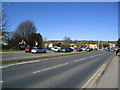
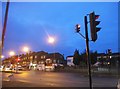
2
A217 Burgh Heath
At the junction with A240 on the left.
Image: © David Howard
Taken: 15 Mar 2009
0.07 miles
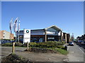
3
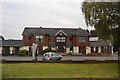
Burgh Heath: Heathside Hotel
A Premier Inn on the A217
Image: © Dr Neil Clifton
Taken: 24 Sep 2014
0.07 miles

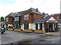
7
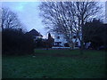
Ballards Green
Modernist 1930s housing estate round the green
Image: © David Howard
Taken: 28 Dec 2009
0.10 miles
8
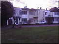
Modernist housing
Ballards Green, Burgh Heath
Image: © David Howard
Taken: 28 Dec 2009
0.10 miles
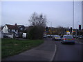
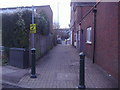
9
Brighton Road at the junction of Reigate Road
Image: © David Howard
Taken: 17 Jan 2016
0.10 miles