IMAGES TAKEN NEAR TO
Trittons, TADWORTH, KT20 5TR
Introduction
This page details the photographs taken nearby to Trittons, KT20 5TR by members of the Geograph project.
The Geograph project started in 2005 with the aim of publishing, organising and preserving representative images for every square kilometre of Great Britain, Ireland and the Isle of Man.

There are currently over 7.5m images from over14,400 individuals and you can help contribute to the project by visiting https://www.geograph.org.uk
Image Map
Images are licensed for reuse under creativecommons.org/licenses/by-sa/2.0
Notes
- Clicking on the map will re-center to the selected point.
- The higher the marker number, the further away the image location is from the centre of the postcode.
Image Listing (5 Images Found)
Images are licensed for reuse under creativecommons.org/licenses/by-sa/2.0
Image
Details
Distance
1
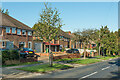
Tadorne Road
c1940s/50s houses in Tadorne Road. Most of the road is shown fully developed on the 1933-38 1:10,560 map, but this section is the exception with no development shown.
Image: © Ian Capper
Taken: 9 Oct 2020
0.14 miles
2
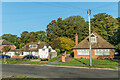
Shelvers Way
c1940s/50s bungalows in Shelvers Way. This part of the road is shown as laid out but without development on the 1933-38 1:10,560 map, although housing elsewhere on the road in shown in outline. The footpath leads through to Bidhams Crescent.
Image: © Ian Capper
Taken: 9 Oct 2020
0.18 miles
3
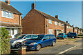
Bidhams Crescent
c1940s/50s houses off Preston Lane.
Image: © Ian Capper
Taken: 9 Oct 2020
0.22 miles
4
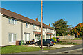
Bidhams Crescent
c1940s/50s houses off Preston Lane.
Image: © Ian Capper
Taken: 9 Oct 2020
0.23 miles
5
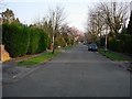
Tadworth (Surrey). Copley Way
A residential upper middle class area in London's leafy suburbs
Image: © Francois Thomas
Taken: 1 Apr 2007
0.24 miles