IMAGES TAKEN NEAR TO
Tadorne Road, TADWORTH, KT20 5TD
Introduction
This page details the photographs taken nearby to Tadorne Road, KT20 5TD by members of the Geograph project.
The Geograph project started in 2005 with the aim of publishing, organising and preserving representative images for every square kilometre of Great Britain, Ireland and the Isle of Man.

There are currently over 7.5m images from over14,400 individuals and you can help contribute to the project by visiting https://www.geograph.org.uk
Image Map
Images are licensed for reuse under creativecommons.org/licenses/by-sa/2.0
Notes
- Clicking on the map will re-center to the selected point.
- The higher the marker number, the further away the image location is from the centre of the postcode.
Image Listing (32 Images Found)
Images are licensed for reuse under creativecommons.org/licenses/by-sa/2.0
Image
Details
Distance
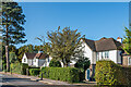
1
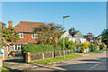
Cross Road
c1920s houses in Cross Road. The road is shown with a few houses on the 1913 1:2,500 map; the ones here are first marked on the 1934 edition.
Image: © Ian Capper
Taken: 9 Oct 2020
0.15 miles
4
Cross Road
c1900s/10s houses in Cross Road. The road is shown with a few houses, including these, on the 1913 1:2,500 map.
Image: © Ian Capper
Taken: 9 Oct 2020
0.19 miles
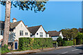
5
Cross Road
c1900s/10s houses in Cross Road. The road is shown with a few houses, including these, on the 1913 1:2,500 map.
Image: © Ian Capper
Taken: 9 Oct 2020
0.19 miles
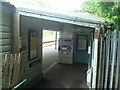
7
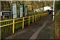
Tadworth Railway Station
The ramp leading down to the London-bound platform.
Image: © Peter Trimming
Taken: 9 Dec 2014
0.23 miles
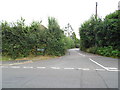
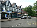
8
Ashurst Road
Mixed age houses in Cross Road. The road is shown (as Station Road) with a few houses on this stretch on the 1913 1:2,500 map (although fully developed on the set side further north). A few more are shown in the 1934 edition, but even then there remain a number of gaps along this section. The name Ashurst Road does not appear until the 1955-69 edition.
Image: © Ian Capper
Taken: 9 Oct 2020
0.23 miles
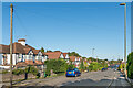
10
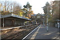
Tadworth station, Surrey
This shows the station looking south from the 'country' end of the Down platform. This side just has a bus shelter, while a large canopy remains on the Up side.
Image: © Dr Neil Clifton
Taken: 16 Nov 2007
0.23 miles