IMAGES TAKEN NEAR TO
Corner Farm Close, TADWORTH, KT20 5SJ
Introduction
This page details the photographs taken nearby to Corner Farm Close, KT20 5SJ by members of the Geograph project.
The Geograph project started in 2005 with the aim of publishing, organising and preserving representative images for every square kilometre of Great Britain, Ireland and the Isle of Man.

There are currently over 7.5m images from over14,400 individuals and you can help contribute to the project by visiting https://www.geograph.org.uk
Image Map
Images are licensed for reuse under creativecommons.org/licenses/by-sa/2.0
Notes
- Clicking on the map will re-center to the selected point.
- The higher the marker number, the further away the image location is from the centre of the postcode.
Image Listing (54 Images Found)
Images are licensed for reuse under creativecommons.org/licenses/by-sa/2.0
Image
Details
Distance
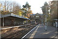
1
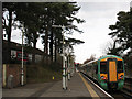
Tadworth station: looking north towards Tattenham Corner
There was originally a five-road goods yard on the Up side, (to the right of the running lines), but this closed on 1962.
Image: © Dr Neil Clifton
Taken: 16 Nov 2007
0.04 miles
2
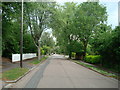
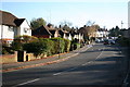
Ashurst Road
Mixed age houses in Cross Road. The road is shown (as Station Road) with a few houses on this stretch on the 1913 1:2,500 map (although fully developed on the set side further north). A few more are shown in the 1934 edition, but even then there remain a number of gaps along this section. The name Ashurst Road does not appear until the 1955-69 edition.
Image: © Ian Capper
Taken: 9 Oct 2020
0.05 miles
3
Tadworth Station
Only a very short layover is allowed at the branch terminus of Tattenham Corner, so it is not long before unit 377 122 is back again working an Up service to London Charing Cross.
Image: © Dr Neil Clifton
Taken: 16 Nov 2007
0.10 miles
4
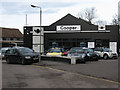
Cooper's car dealership, Tadworth
This dealer seems mainly to sell Mini Coopers, which may explain the name.
Image: © Stephen Craven
Taken: 1 Feb 2010
0.11 miles
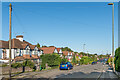
5
Ashurst Road, Tadworth
This road is part of the B290 here. In spite of the speed bumps, the 460 bus service from Epsom to Redhill uses this road.
Image: © Dr Neil Clifton
Taken: 16 Nov 2007
0.12 miles
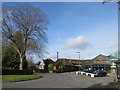
6
Holsart Close
This is the closest I could reasonably take a photograph of the private Holsart Close off Kingswood Road. The railway between Tadworth and Tattenham Corner runs behind the trees in the background on an embankment.
Image: © Marathon
Taken: 14 Aug 2013
0.12 miles
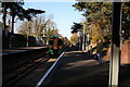
7
Tadworth station with Oyster reader
A similar view to Image looking north at the station. What is new is the Oyster card reader against the brick wall at left. Oyster smartcards were only introduced to the Network Rail lines in Greater London in January 2010. the Tattenham Corner branch actually goes several miles outside Greater London but is still in Travelcard Zone 6.
The train is a Sunday service from London Bridge to Tattenham Corner, running late due to being diverted via Streatham for engineering works on the main line.
Image: © Stephen Craven
Taken: 1 Feb 2010
0.12 miles
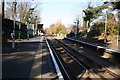
8
Tadworth station, Surrey
This shows the station looking south from the 'country' end of the Down platform. This side just has a bus shelter, while a large canopy remains on the Up side.
Image: © Dr Neil Clifton
Taken: 16 Nov 2007
0.12 miles
9
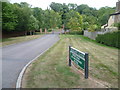
The Avenue, Tadworth
The Avenue outside Tadworth railway station, photographed on a clear and sunny February day.
Image: © Malc McDonald
Taken: 9 Feb 2019
0.13 miles