IMAGES TAKEN NEAR TO
Vernon Walk, TADWORTH, KT20 5QP
Introduction
This page details the photographs taken nearby to Vernon Walk, KT20 5QP by members of the Geograph project.
The Geograph project started in 2005 with the aim of publishing, organising and preserving representative images for every square kilometre of Great Britain, Ireland and the Isle of Man.

There are currently over 7.5m images from over14,400 individuals and you can help contribute to the project by visiting https://www.geograph.org.uk
Image Map
Images are licensed for reuse under creativecommons.org/licenses/by-sa/2.0
Notes
- Clicking on the map will re-center to the selected point.
- The higher the marker number, the further away the image location is from the centre of the postcode.
Image Listing (6 Images Found)
Images are licensed for reuse under creativecommons.org/licenses/by-sa/2.0
Image
Details
Distance
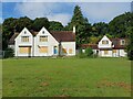
2
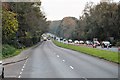
Tadworth (Surrey). Copley Way
A residential upper middle class area in London's leafy suburbs
Image: © Francois Thomas
Taken: 1 Apr 2007
0.14 miles
4
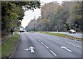
Old Copthorne House, Kingswood
Previously a retirement flats building. 'Old' to distinguish it from the 'new' blocks of flats built in 1973.
Image: © Oscar Taylor
Taken: 14 Aug 2024
0.18 miles
5
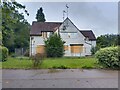
Old Copthorne House, Kingswood
Previously a retirement flats building. 'Old' to distinguish it from the 'new' blocks of flats built in 1973.
Image: © Oscar Taylor
Taken: 14 Aug 2024
0.18 miles