IMAGES TAKEN NEAR TO
Chetwode Road, TADWORTH, KT20 5PJ
Introduction
This page details the photographs taken nearby to Chetwode Road, KT20 5PJ by members of the Geograph project.
The Geograph project started in 2005 with the aim of publishing, organising and preserving representative images for every square kilometre of Great Britain, Ireland and the Isle of Man.

There are currently over 7.5m images from over14,400 individuals and you can help contribute to the project by visiting https://www.geograph.org.uk
Image Map
Images are licensed for reuse under creativecommons.org/licenses/by-sa/2.0
Notes
- Clicking on the map will re-center to the selected point.
- The higher the marker number, the further away the image location is from the centre of the postcode.
Image Listing (22 Images Found)
Images are licensed for reuse under creativecommons.org/licenses/by-sa/2.0
Image
Details
Distance
1
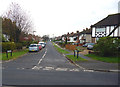
Burgh Heath: Elm Gardens
This is a cul-de-sac, seen looking east from St. Leonard's Road
Image: © Dr Neil Clifton
Taken: 25 Nov 2014
0.11 miles
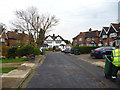
2
Burgh Heath: St. Leonard's Road
Looking south from Chapel Way
Image: © Dr Neil Clifton
Taken: 25 Nov 2014
0.12 miles
3
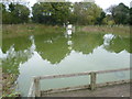
Marbles Pond
A surprising find in the middle of a housing estate, this pond is presumably a relic from the time when this was part of Burgh Heath. It is to be found down Marbles Way next to Merefield Gardens. A heron is sitting on the notice in the middle of the pond.
Image: © Marathon
Taken: 7 Nov 2013
0.15 miles
4
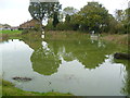
Marbles Pond, Burgh Heath
A surprising find in the middle of a housing estate, this pond is presumably a relic from the time when this was part of Burgh Heath. It is to be found down Marbles Way next to Merefield Gardens. A heron is sitting on the notice in the middle of the pond.
Image: © Marathon
Taken: 7 Nov 2013
0.15 miles
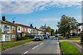
5
Burgh Heath: Chapel Way
Looking east from Merland Rise
Image: © Dr Neil Clifton
Taken: 25 Nov 2014
0.16 miles
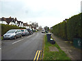
6
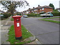
Post box in Chapel Way
St Leonards Road is on the right.
Image: © Marathon
Taken: 7 Nov 2013
0.17 miles
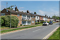
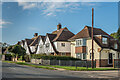
7
Chetwode Road
c1930s or 1940s housing. The road is first shown in outline but with no development on the 1938-45 1:10,560 map.
Image: © Ian Capper
Taken: 9 Oct 2020
0.17 miles
9
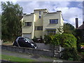
Modernist house on Chapel Way, Tattenham Corner
Image: © David Howard
Taken: 12 Jul 2009
0.21 miles
10
Merland Rise
c1930s housing. The road is first shown with some outline development on the 1938-45 1:10,560 map but does not appear on the 1934 1:2,500 map.
Image: © Ian Capper
Taken: 9 Oct 2020
0.21 miles