IMAGES TAKEN NEAR TO
Morston Close, TADWORTH, KT20 5JN
Introduction
This page details the photographs taken nearby to Morston Close, KT20 5JN by members of the Geograph project.
The Geograph project started in 2005 with the aim of publishing, organising and preserving representative images for every square kilometre of Great Britain, Ireland and the Isle of Man.

There are currently over 7.5m images from over14,400 individuals and you can help contribute to the project by visiting https://www.geograph.org.uk
Image Map
Images are licensed for reuse under creativecommons.org/licenses/by-sa/2.0
Notes
- Clicking on the map will re-center to the selected point.
- The higher the marker number, the further away the image location is from the centre of the postcode.
Image Listing (30 Images Found)
Images are licensed for reuse under creativecommons.org/licenses/by-sa/2.0
Image
Details
Distance
1
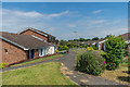
Headley Grove
Bungalows in a development off Merland Rise.
Image: © Ian Capper
Taken: 8 Jun 2018
0.08 miles
2
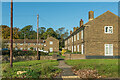
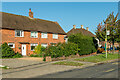
Merland Green
c1940s/50s houses off Merland Rise.
Image: © Ian Capper
Taken: 9 Oct 2020
0.13 miles
3
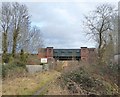
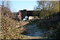
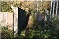
Railway bridge south of Tattenham Corner
This rather neglected footpath must once have been a wide, well-used farm-track. Why else would the South Eastern & Chatham Railway (arriving circa 1900) have built such a substantial bridge? There is clearance enough for a hay-wagon - foot-traffic and livestock could have been accommodated by a tunnel with much less headroom.
Or perhaps there was quarry traffic- I notice that the name of a patch of woodland east of the railway is given by the OS as Pit Wood.
The line runs north to its terminus at Tattenham Corner, south to Tadworth (before turning north-east towards Purley and London).
Image: © Stefan Czapski
Taken: 18 Jan 2018
0.13 miles
4
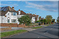
Merland Rise
c1940s/50s houses in Merland Rise. This part of the road is shown as laid out but without development on the 1933-38 1:10,560 map.
Image: © Ian Capper
Taken: 9 Oct 2020
0.13 miles
5
Bridge over a public footpath
Looking eastwards here from the B290 is seen the overbridge carrying the Tattenham Corner railway line over a rather untidy footpath which links to the suburban housing of Banstead.
Image: © Dr Neil Clifton
Taken: 16 Nov 2007
0.14 miles
6
Merland Rise
c1930s or 1940s housing. The road is first shown with some outline development north of this section on the 1938-45 1:10,560 map, but this section is shown only with the road marked.
Image: © Ian Capper
Taken: 9 Oct 2020
0.15 miles
7
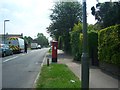
Post Box
Post Box KT18 197 Merland Rise / Chetwode Road
Image: © The Saunterer
Taken: 29 May 2012
0.15 miles
8
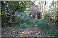
Footpath. looking north
This public footpath can be used to walk from Tattenham Corner station to Tadworth station or vice versa, but its northern end is rather difficult to find from Tattenham Corner.
Image: © Dr Neil Clifton
Taken: 16 Nov 2007
0.15 miles
9
Footpath, looking north
The footpath linking Tattenham Corner station with Tadworth station continues on the east side of the railway as a pleasant leaf-strewn way, generally free of litter and dog faeces. This photograph looks back towards Tattenham Corner.
Image: © Dr Neil Clifton
Taken: 16 Nov 2007
0.16 miles