IMAGES TAKEN NEAR TO
Epsom Lane North, TADWORTH, KT20 5ER
Introduction
This page details the photographs taken nearby to Epsom Lane North, KT20 5ER by members of the Geograph project.
The Geograph project started in 2005 with the aim of publishing, organising and preserving representative images for every square kilometre of Great Britain, Ireland and the Isle of Man.

There are currently over 7.5m images from over14,400 individuals and you can help contribute to the project by visiting https://www.geograph.org.uk
Image Map
Images are licensed for reuse under creativecommons.org/licenses/by-sa/2.0
Notes
- Clicking on the map will re-center to the selected point.
- The higher the marker number, the further away the image location is from the centre of the postcode.
Image Listing (22 Images Found)
Images are licensed for reuse under creativecommons.org/licenses/by-sa/2.0
Image
Details
Distance
1
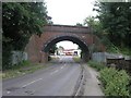
Railway Bridge near Tadworth
This railway bridge carries the railway to Tattenham Corner, which serves Epsom Downs race course.
Image: © Hywel Williams
Taken: 8 Jul 2005
0.02 miles
2

Railway bridge over the B290
This bridge carries the Tattenham Corner railway over the B290. Epsom Racecourse is ahead, and Tadworth behind, in this photograph.
Image: © Dr Neil Clifton
Taken: 16 Nov 2007
0.04 miles
3
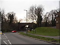
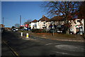
Preston Lane at the junction of Shelvers Hill
Image: © David Howard
Taken: 30 Mar 2014
0.06 miles
4
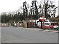
Tadworth Tyres on Shelvers Hill
Backing on to the railway line
Image: © David Howard
Taken: 30 Mar 2014
0.06 miles
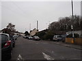
6
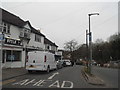
Shelvers Hill, Tadworth
Residents around here are favoured, because this small parade of shops includes a Post Office.
Image: © Dr Neil Clifton
Taken: 16 Nov 2007
0.09 miles
7
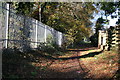
Footpath looking north near railway bridge
The pleasant footpath linking Tattenham Corner station with Tadworth station emerges onto the road just east of the railway bridge carrying the Tattenham Corner line over the B290. This is looking back northwards at the end of the path, with high-security fencing protecting the railway line from children.
Image: © Dr Neil Clifton
Taken: 16 Nov 2007
0.10 miles
9
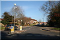
Preston Lane, Tadworth, Surrey
Preston Lane is a quiet suburban road running northeast from the B290 towards Banstead. This shows it from the B290 end.
Image: © Dr Neil Clifton
Taken: 16 Nov 2007
0.13 miles
10
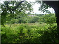
View from footpath leading away from Kingswood Road
This path leads from Kingswood Road towards Walton Downs. It has views over the Green Belt to the south-west in the direction of Headley. The houses ahead are on the outskirts of Tadworth.
Image: © Marathon
Taken: 14 Aug 2013
0.13 miles