IMAGES TAKEN NEAR TO
Avenue Close, TADWORTH, KT20 5DF
Introduction
This page details the photographs taken nearby to Avenue Close, KT20 5DF by members of the Geograph project.
The Geograph project started in 2005 with the aim of publishing, organising and preserving representative images for every square kilometre of Great Britain, Ireland and the Isle of Man.

There are currently over 7.5m images from over14,400 individuals and you can help contribute to the project by visiting https://www.geograph.org.uk
Image Map
Images are licensed for reuse under creativecommons.org/licenses/by-sa/2.0
Notes
- Clicking on the map will re-center to the selected point.
- The higher the marker number, the further away the image location is from the centre of the postcode.
Image Listing (72 Images Found)
Images are licensed for reuse under creativecommons.org/licenses/by-sa/2.0
Image
Details
Distance
1
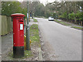
Post box on The Avenue, Tadworth
The Georgian postbox helps to date the housing in the area, which was developed in the early 20th century after the coming of the railway in 1901.
Image: © Stephen Craven
Taken: 1 Feb 2010
0.08 miles
2
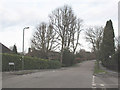
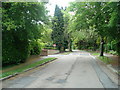
Downs Way, Tadworth
Typical of the suburban streets in this area.
Image: © Stephen Craven
Taken: 1 Feb 2010
0.10 miles
3
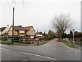
Kingswood Road, Tadworth
Kingswood Road is a residential road in Tadworth, in Surrey.
Image: © Malc McDonald
Taken: 9 Feb 2019
0.11 miles
4
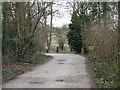
Motts Hill Lane, Tadworth
A stone-surfaced track lining The Avenue and Ebbisham Lane. The runner at the end is taking part in an organised race- see Image
Image: © Stephen Craven
Taken: 1 Feb 2010
0.13 miles
6
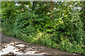
Coal Tax Post no 135
Hidden in this hedge alongside Motts Hill Lane is a Coal Tax Post (no 135 on the list linked to below) is hidden in a laurel hedge - not the easiest one to locate.
For a close up of the post itself, see Image
Image: © Ian Capper
Taken: 8 Jun 2014
0.14 miles
7
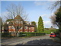
Spindlewoods, Tadworth
Spindlewoods is a residential development in Tadworth, in Surrey.
Long shadows and bare trees are a sign that this image was taken during the winter months.
Image: © Malc McDonald
Taken: 9 Feb 2019
0.14 miles
8
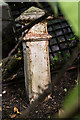
Coal Tax Post no 135
This Coal Tax Post (no 135 on the list linked to below) is hidden in a laurel hedge on the edge of a garden alongside Motts Hill Lane. Its situation means that it is not possible to photograph without some foliage getting in the way.
For a photo of its situation see Image
Image: © Ian Capper
Taken: 8 Jun 2014
0.14 miles
9
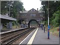
Tadworth Station
Tadworth station from the platform that runs to Tattenham Corner, looking towards London direction.
Image: © Hywel Williams
Taken: 20 Jun 2005
0.14 miles
10
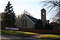
Roman Catholic Church of St. John the Evangelist, The Avenue, Tadworth
On the west side of Tadworth station
Image: © Dr Neil Clifton
Taken: 16 Nov 2007
0.15 miles