IMAGES TAKEN NEAR TO
Milstead Close, TADWORTH, KT20 5AX
Introduction
This page details the photographs taken nearby to Milstead Close, KT20 5AX by members of the Geograph project.
The Geograph project started in 2005 with the aim of publishing, organising and preserving representative images for every square kilometre of Great Britain, Ireland and the Isle of Man.

There are currently over 7.5m images from over14,400 individuals and you can help contribute to the project by visiting https://www.geograph.org.uk
Image Map
Images are licensed for reuse under creativecommons.org/licenses/by-sa/2.0
Notes
- Clicking on the map will re-center to the selected point.
- The higher the marker number, the further away the image location is from the centre of the postcode.
Image Listing (73 Images Found)
Images are licensed for reuse under creativecommons.org/licenses/by-sa/2.0
Image
Details
Distance
1
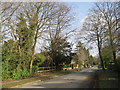
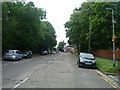
The Avenue, Tadworth
The Avenue is a residential road in Tadworth, in Surrey.
This image was taken on a bright and sunny February day. Bare trees and long shadows are a sign that this winter.
Image: © Malc McDonald
Taken: 9 Feb 2019
0.08 miles
2
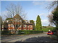
Spindlewoods, Tadworth
Spindlewoods is a residential development in Tadworth, in Surrey.
Long shadows and bare trees are a sign that this image was taken during the winter months.
Image: © Malc McDonald
Taken: 9 Feb 2019
0.08 miles
3
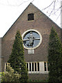
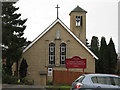
Church of the Good Shepherd, Tadworth: west end
The Anglican church of the Good Shepherd, built in 1912 and granted parish church status in 1955, was extended by one bay at the west end as a golden jubilee project in 1962/3, with this circular west window portraying Christ the Good Shepherd. The lamb below the window also echoes the traditional depiction of Christ as the sacrificial "lamb of God".
For the other end of the church see Image
Image: © Stephen Craven
Taken: 23 Feb 2010
0.09 miles
4
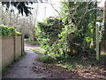
Public bridleway in Tadworth
A public bridleway in Tadworth, in Surrey.
Image: © Malc McDonald
Taken: 9 Feb 2019
0.09 miles
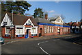
6
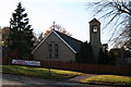
Roman Catholic Church of St. John the Evangelist, The Avenue, Tadworth
On the west side of Tadworth station
Image: © Dr Neil Clifton
Taken: 16 Nov 2007
0.09 miles
7
St John the Evangelist, Tadworth
A Roman Catholic church close to the railway station, opened in 1966.
Image: © Stephen Craven
Taken: 1 Feb 2010
0.09 miles
8
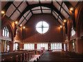
Church of the Good Shepherd, Tadworth: nave
The interior of the church, looking west. For a brief history see Image
Image: © Stephen Craven
Taken: 23 Feb 2010
0.10 miles
9
Tadworth church hall
The hall is on Station Approach Road, adjacent to the Anglican church Image just over the grid line to the south.
Image: © Stephen Craven
Taken: 23 Feb 2010
0.10 miles
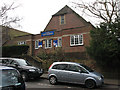
10
Tadworth Station
The branch line from Purley to Tadworth was opened on 1 July 1900 in what was then a very sparsely-populated area. Extension to Tattenham Corner followed in 1901 and the branch became immediately popular with racegoers and also for excursions to the countryside hereabouts. Electrification took place in March 1928 on the third-rail system. The buildings shown here are not now in railway use, nor have been for many years. Sadly there has been vandalism with broken windows etc.
Image: © Dr Neil Clifton
Taken: 16 Nov 2007
0.10 miles