IMAGES TAKEN NEAR TO
Green Lanes, EPSOM, KT19 9TN
Introduction
This page details the photographs taken nearby to Green Lanes, KT19 9TN by members of the Geograph project.
The Geograph project started in 2005 with the aim of publishing, organising and preserving representative images for every square kilometre of Great Britain, Ireland and the Isle of Man.

There are currently over 7.5m images from over14,400 individuals and you can help contribute to the project by visiting https://www.geograph.org.uk
Image Map
Images are licensed for reuse under creativecommons.org/licenses/by-sa/2.0
Notes
- Clicking on the map will re-center to the selected point.
- The higher the marker number, the further away the image location is from the centre of the postcode.
Image Listing (36 Images Found)
Images are licensed for reuse under creativecommons.org/licenses/by-sa/2.0
Image
Details
Distance
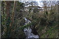
1
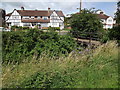
Green Lanes
Mock Tudor housing facing a long straight and grassy reach of the Hogsmill River in Ewell.
www.epsomandewellhistoryexplorer.org.uk
Image: © Colin Smith
Taken: 17 Jul 2012
0.02 miles
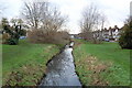
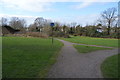
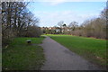
6
Chamber Mead
Entering parkland in Ewell, a long grassy strip bordering the Hogsmill River.
www.epsomandewellhistoryexplorer.org.uk
Image: © Colin Smith
Taken: 17 Jul 2012
0.12 miles
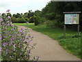
9

Oak tree on edge of Hogsmill Open Space, West Ewell
One of a number of magnificent oaks in this vicinity.
Image: © Roger Miller
Taken: 25 Dec 2005
0.14 miles