IMAGES TAKEN NEAR TO
Wey Court, EPSOM, KT19 9PY
Introduction
This page details the photographs taken nearby to Wey Court, KT19 9PY by members of the Geograph project.
The Geograph project started in 2005 with the aim of publishing, organising and preserving representative images for every square kilometre of Great Britain, Ireland and the Isle of Man.

There are currently over 7.5m images from over14,400 individuals and you can help contribute to the project by visiting https://www.geograph.org.uk
Image Map
Images are licensed for reuse under creativecommons.org/licenses/by-sa/2.0
Notes
- Clicking on the map will re-center to the selected point.
- The higher the marker number, the further away the image location is from the centre of the postcode.
Image Listing (33 Images Found)
Images are licensed for reuse under creativecommons.org/licenses/by-sa/2.0
Image
Details
Distance
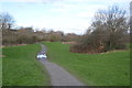
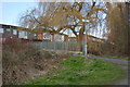
4
Hogsmill Open Space
The building straight ahead is Image on the A3.
Image: © Roger Miller
Taken: 2 Aug 2005
0.06 miles
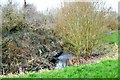
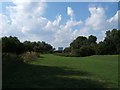
7
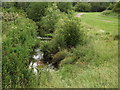
Ewell, Hogsmill River
Leafy stream flowing towards the Green Belt between Ewell and Kingston-upon-Thames.
Image: © Colin Smith
Taken: 3 Jul 2012
0.10 miles
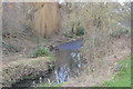
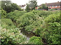
9
Hogsmill River, Ewell
A very narrow stream with the level of a river in its name. Here it flows through parkland.
Image: © Colin Smith
Taken: 3 Jul 2012
0.14 miles
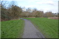
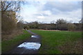
10
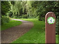
London Loop, Ewell
London Outer Orbital Path (LOOP), here following the bank of the River Hogsmill.
http://www.walklondon.org.uk/route.asp?R=5
Image: © Colin Smith
Taken: 3 Jul 2012
0.14 miles