IMAGES TAKEN NEAR TO
Stanton Close, EPSOM, KT19 9NP
Introduction
This page details the photographs taken nearby to Stanton Close, KT19 9NP by members of the Geograph project.
The Geograph project started in 2005 with the aim of publishing, organising and preserving representative images for every square kilometre of Great Britain, Ireland and the Isle of Man.

There are currently over 7.5m images from over14,400 individuals and you can help contribute to the project by visiting https://www.geograph.org.uk
Image Map
Images are licensed for reuse under creativecommons.org/licenses/by-sa/2.0
Notes
- Clicking on the map will re-center to the selected point.
- The higher the marker number, the further away the image location is from the centre of the postcode.
Image Listing (4 Images Found)
Images are licensed for reuse under creativecommons.org/licenses/by-sa/2.0
Image
Details
Distance
2
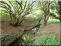
A secret border crossing
London on the left bank, Surrey on the right, with some attempt at stepping stones to cross. The stream is small and only one stone would do, but I didn't try, as the left bank looked a bit steep and slippery.
Image: © Robin Webster
Taken: 4 Sep 2012
0.19 miles
3
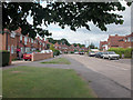
Rowden Road
Off Cox lane close to Hogsmill River.
Image: © Dennis Turner
Taken: 20 Aug 2005
0.21 miles