IMAGES TAKEN NEAR TO
Almond Road, EPSOM, KT19 9DS
Introduction
This page details the photographs taken nearby to Almond Road, KT19 9DS by members of the Geograph project.
The Geograph project started in 2005 with the aim of publishing, organising and preserving representative images for every square kilometre of Great Britain, Ireland and the Isle of Man.

There are currently over 7.5m images from over14,400 individuals and you can help contribute to the project by visiting https://www.geograph.org.uk
Image Map
Images are licensed for reuse under creativecommons.org/licenses/by-sa/2.0
Notes
- Clicking on the map will re-center to the selected point.
- The higher the marker number, the further away the image location is from the centre of the postcode.
Image Listing (12 Images Found)
Images are licensed for reuse under creativecommons.org/licenses/by-sa/2.0
Image
Details
Distance
1

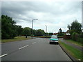
A long mead by Longmead Road
A path and stream pass along a long strip of green on the east side of the road.
Image: © Robin Webster
Taken: 10 Apr 2012
0.07 miles

5
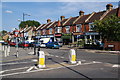
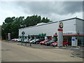
Row of shops on Pound Lane
Seen from the junction with Lower Court Road. The traffic bollards look a bit misshapen.
Image: © Bill Boaden
Taken: 1 Aug 2011
0.17 miles
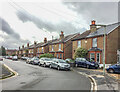
6
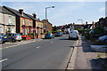
Lower Court Road
On the left is a string of older small semis , showing that this is a longstanding residential road.
Image: © Bill Boaden
Taken: 1 Aug 2011
0.19 miles
7
Miles Road
Late 19th/early 20th Century housing, first marked on the 1913 25 inch map. Each of these semi-detached pairs have name/date plaques; in order from right to left they are: Ellison Cottages 1899, Stanmore Cottages 1899, Lorraine Cottages 1899, Ventnor Cottages 1899, Carisbrook (sic) Cottages 1899, Glenco (sic) Cottages 1899 and Belmont Cottages 1901.
Image: © Ian Capper
Taken: 4 Oct 2019
0.23 miles
8
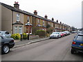
Epsom: Upper Court Road
Neat Victorian semi-detached houses on the east side of Upper Court Road.
Image: © Nigel Cox
Taken: 16 Mar 2006
0.24 miles

10
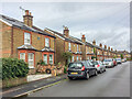
Miles Road
Late 19th/early 20th Century housing, first marked on the 1913 25 inch map. Each of these semi-detached pairs have name/date plaques; in order from left to right they are: Belmont Cottages 1901, Glenco (sic) Cottages 1899, Carisbrook (sic) Cottages 1899, Ventnor Cottages 1899, Lorraine Cottages 1899, Stanmore Cottages 1899 and Ellison Cottages 1899.
Image: © Ian Capper
Taken: 4 Oct 2019
0.24 miles