IMAGES TAKEN NEAR TO
Andover Close, EPSOM, KT19 9DA
Introduction
This page details the photographs taken nearby to Andover Close, KT19 9DA by members of the Geograph project.
The Geograph project started in 2005 with the aim of publishing, organising and preserving representative images for every square kilometre of Great Britain, Ireland and the Isle of Man.

There are currently over 7.5m images from over14,400 individuals and you can help contribute to the project by visiting https://www.geograph.org.uk
Image Map
Images are licensed for reuse under creativecommons.org/licenses/by-sa/2.0
Notes
- Clicking on the map will re-center to the selected point.
- The higher the marker number, the further away the image location is from the centre of the postcode.
Image Listing (7 Images Found)
Images are licensed for reuse under creativecommons.org/licenses/by-sa/2.0
Image
Details
Distance

4
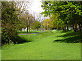
A long mead by Longmead Road
A path and stream pass along a long strip of green on the east side of the road.
Image: © Robin Webster
Taken: 10 Apr 2012
0.15 miles
5
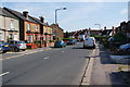
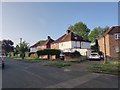
Lower Court Road
On the left is a string of older small semis , showing that this is a longstanding residential road.
Image: © Bill Boaden
Taken: 1 Aug 2011
0.18 miles
7
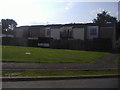
Rear of houses on Harvester Way, Epsom
I took these mainly as the rear of the houses had so few windows and wondered how the rooms upstairs got any light.
Image: © David Howard
Taken: 9 Aug 2009
0.22 miles