IMAGES TAKEN NEAR TO
Kendor Avenue, EPSOM, KT19 8RH
Introduction
This page details the photographs taken nearby to Kendor Avenue, KT19 8RH by members of the Geograph project.
The Geograph project started in 2005 with the aim of publishing, organising and preserving representative images for every square kilometre of Great Britain, Ireland and the Isle of Man.

There are currently over 7.5m images from over14,400 individuals and you can help contribute to the project by visiting https://www.geograph.org.uk
Image Map
Images are licensed for reuse under creativecommons.org/licenses/by-sa/2.0
Notes
- Clicking on the map will re-center to the selected point.
- The higher the marker number, the further away the image location is from the centre of the postcode.
Image Listing (5 Images Found)
Images are licensed for reuse under creativecommons.org/licenses/by-sa/2.0
Image
Details
Distance
1
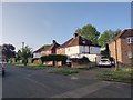
Epsom: Horton Gardens
A cupola adorns the top of the central houses in this curved terrace off Horton Hill.
Image: © Nigel Cox
Taken: 16 Mar 2006
0.08 miles
2
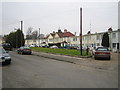
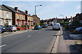
Epsom: Upper Court Road
Neat Victorian semi-detached houses on the east side of Upper Court Road.
Image: © Nigel Cox
Taken: 16 Mar 2006
0.13 miles
3
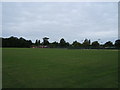
Court Recreation Ground, Epsom
Taken from approx TQ 206 613.
Image: © Roger Miller
Taken: 27 Aug 2005
0.20 miles
4
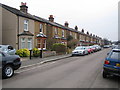
Lower Court Road
On the left is a string of older small semis , showing that this is a longstanding residential road.
Image: © Bill Boaden
Taken: 1 Aug 2011
0.21 miles