IMAGES TAKEN NEAR TO
Cuddington Glade, EPSOM, KT19 8NN
Introduction
This page details the photographs taken nearby to Cuddington Glade, KT19 8NN by members of the Geograph project.
The Geograph project started in 2005 with the aim of publishing, organising and preserving representative images for every square kilometre of Great Britain, Ireland and the Isle of Man.

There are currently over 7.5m images from over14,400 individuals and you can help contribute to the project by visiting https://www.geograph.org.uk
Image Map
Images are licensed for reuse under creativecommons.org/licenses/by-sa/2.0
Notes
- Clicking on the map will re-center to the selected point.
- The higher the marker number, the further away the image location is from the centre of the postcode.
Image Listing (14 Images Found)
Images are licensed for reuse under creativecommons.org/licenses/by-sa/2.0
Image
Details
Distance
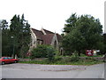
1
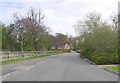
Cuddington Glade
A small low density development of small four bedroom terraced houses.This was a former site of nursing accommodation for a local NHS Trust in a very attractive location on the edge of Epsom Common, within a 10 minute walk of Epsom High Street. Countrywide Design carried out a program of high quality refurbishment and specification of the properties to provide 13 four bed homes each of around 1300 square foot.
Image: © Nigel Mykura
Taken: 17 Apr 2015
0.03 miles
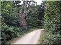
2
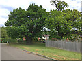
Two ancient oaks
Two ancient oak trees at the corner of Cuddington Glade and the old carriage drive to the Manor hospital estate. The carriage drive, which formed the approach from Epsom town centre, has been preserved as a shared-use cycle track. The oaks are of substantial girth, and must long predate the Horton psychiatric hospital development. Both are subject to tree preservation orders.
Image: © Hugh Craddock
Taken: 3 May 2020
0.04 miles
3
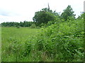
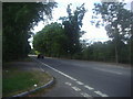
Field next to Horton Lane
This field lies between Horton Lane, Chertsey Lane and the B280. It is not officially accessible. Here Horton Lane is on the right and the B280 is in the distance.
Image: © Marathon
Taken: 21 May 2014
0.15 miles
4
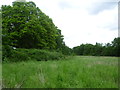
Field next to Horton Lane
This field lies between Horton Lane, Chertsey Lane and the B280. It is not officially accessible. Here Horton Lane is on the left.
Image: © Marathon
Taken: 21 May 2014
0.15 miles
5
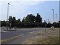
Roundabout on B280 close to Epsom Common
Image: © James Emmans
Taken: 18 Aug 2016
0.16 miles
6
Horton Lane, Epsom
This used to lead to the hospital complex but is now all a new housing estate
Image: © David Howard
Taken: 20 Aug 2012
0.17 miles
7
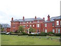
Horton Manor House
This building, now luxury apartments, was formerly known as Horton Manor. In 1899 it became the centre of an asylum for the mentally ill, and was later used as a certified institution for the mentally handicapped. It closed in 1996 and has since been incorporated into a housing development that covers most of this grid square.
Image: © Dan Gregory
Taken: 7 Sep 2009
0.19 miles
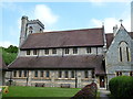
10
Christ Church, Epsom Common
Originally a chapel of ease to Image, Christ Church was built in 1876 (more about the history: http://www.christchurchepsom.org.uk/church%20history.htm ).
Image: © Roger Miller
Taken: 27 Aug 2005
0.21 miles